In compliance with FTC
guidelines, please assume
the following about all links
on this website: Since I share
products and services I use
and love with my readers,
assume that I may receive a
small commision if you buy
something or subscribe to a
service from a link on this
website (at no additional cost
to you). If you do buy some-
thing, thanks for your
support!
Among others, we are a
participant in the Amazon
Services LLC Associates
Program, an affiliate
advertising program designed
to provide a means for us to
earn fees by linking to
Amazon.com and affiliated
sites. Pages on this site may
include affiliate links to
Amazon and its affiliate sites
on which the owner of this
website may make a referral
commission.
Channel Islands National Park is made up of five ecologically rich islands off the Southern California coast and their surrounding one mile of the ocean.
Accessible by boat or plane, the Channel Islands are rarely crowded, but peak times are June–August. The climate is mild year-round.
Swimming, snorkeling, diving, kayaking and whale-watching (blue and humpback) are common activities June–September.
Established: March 5, 1980 Area: 390 mi² Mailing Address:
1901 Spinnaker Drive
Ventura, CA 93001 Phone: (805) 658-5730The islands, especially Santa Rosa and San Miguel, can be windy, but less so in summer and early fall (strong Santa Ana winds can happen anytime). Fog is also common. Winter is cooler, with a chance of storms December–March. Gray whale-watching season runs December–April.
Anacapa Island
Anacapa Island has trails to a 1932 lighthouse and clifftop Inspiration Point.
Anacapa Island – Chanel Islands National Park Buy this print
Just 13 miles from the Channel Islands National Park Visitor Center in Ventura, Anacapa Island is the second smallest of the Channel Islands at roughly five miles long and one-half mile wide.
The native Chumash once called this island “Ennepah,” a word meaning deception or mirage which alluded to this island’s changing shape when viewed at different times from the mainland and other islands.
Anacapa is actually a narrow chain of three islands appropriately called East, Middle, and West Anacapa. Emerging from the fog of the Santa Barbara Channel, Anacapa Island drifts in and out of sight, beckoning visitors from the mainland as it has for centuries.
Chumash on Anacapa
Archeological evidence suggests that the native Chumash people were visiting Anacapa Island as long as 5,000 years ago. Abalone and mussel shells, bones from fish, birds, and pinnipeds, and human artifacts such as bone tools, shell beads, projectile points, and fish hooks all suggest extensive human activity on the island.
Due to the absence of fresh water on the island, it is likely that seasonal camps were used for fishing and other activities.
Despite the lack of archeological evidence of permanent settlements on the island, Chumash legend holds that the American Indian population of the Channel Islands began on Anacapa.
In the early 20thcentury, anthropologist John Harrington extensively interviewed a Mission San Buenaventura Chumash man named Fernando Librado who told Harrington a story passed on orally through generations of Chumash Indians.
According to the story, eight families traveled to Anacapa Island after a civil war on the mainland and settled on the north side of the middle island. For water, they dug a hole and used seepage at Indian Cave on West Anacapa.
After a time, the eight families left Anacapa for Santa Cruz Island, eventually spreading to all the northern islands.
European Contact
Juan Rodriguez Cabrillo was the first European explorer to make contact with the Channel Islands in 1542. Although he passed Anacapa, he and his crew never settled there. Cabrillo named the northern IslandsLas Islas de San Lucas,which included Anacapa.
Learning that there were no American Indians on the island, few European explorers visited Anacapa the following decades. Its small size and relative unimportance left the island largely unrecorded for a period of 250 years.
The 1793 expedition by Englishman George Vancouver standardized the names of the Channel Islands. Vancouver recorded Anacapa as “Enecapa” and the present spelling appeared on maps in 1854.
Ranching
Like many of the other Channel Islands, Anacapa Island was used for sheep ranching during the latter half of the 19thcentury. It is uncertain exactly when ranching began on Anacapa. It is believed that three men owned ranches prior to the first recorded lease which began in 1902.
H. Bay Webster, himself a sheep rancher on the island, recalled that the first sheep ranch had been established by George Nidever before 1885, although he may have been confused with events onSanMiguelIsland.
Ranchers used Middle Anacapa for the main headquarters of their sheep operations and the livestock were landed on the northwest side of the island. Sheep survived year-round, but on a marginal basis.
With no dependable supply of fresh water, many recalled the somewhat dubious story that the sheep would lick the moisture from the morning fog off of each other’s coats.
To improve grazing, sheep ranchers introduced exotic grasses to the island. By the 1930s the sheep had destroyed most of the native plants and had begun to eat the endemicAstragalus miguelensis.
As a result, many of the sheep died, bringing an end to sheep herding on Anacapa.
Residents
Heaman Bayfield Webster, a former island seal hunter, long-time Ventura resident and assistant postmaster, established residence on Middle Anacapa with his wife and two sons in 1907.
For $31 per year, he leased all three of the islands “for grazing and farming only,” establishing the first government-recorded ranch on Anacapa. The family spent summers and two winters on the island tending to a flock of nearly 300 sheep.
In the fall of 1911, Webster set up a school in a tent for his children and hired a governess to teach them, the first school house on the Channel Islands. Most of Webster’s income came from tourism and wool.
Perhaps the most illustrious resident of Anacapa Island was Raymond “Frenchy” LeDreau. The Frenchman made his way to the island in 1928, taking up the life of a fisherman and hermit. He built several huts perched on a ledge overlooking the area now called Frenchy’s Cove.
Focusing on lobster fishing, Frenchy sold fish to passing Larco Company boats and hosted visitors and fisherman passing by. Friends old and new brought him food and supplies in return for lobster, abalone, and conversation. He was an educated man, apt to discuss literature and sing an aria in a tenor voice.
During prohibition he made money by watching over caches of liquor stored in many of Anacapa’s caves by rumrunners and bootleggers.
When the US Government created the Channel Islands National Monument in 1938, which included both Anacapa and Santa Barbara islands, it appeared that Frenchy might be forced to leave.
So impressed, however, was National Park Service biologist Lowell Sumner with LeDreau’s concern for the natural history and welfare of the island that Lowell suggested LeDreau “be allowed to remain on the island as long as he desires.”
Frenchy became the de-facto caretaker of Anacapa Island for the National Park Service until 1956 when, at the age of 80, he was forced to leave after a fall left him with severe injuries. He had lived on Anacapa Island for 28 years.
In 1932, theAnacapa Island Light Station was completed on East Anacapa Island, but not before the treacherously rocky coastline churned up several shipwrecks, including the Winfield Scott, of which the remains can be seen right off of Anacapa’s shores.
The lighthouse and fog signal are still operated by the US Coast Guard and the originalFresnel lens is on display in the island’s visitor center.
There are many other interesting stories about Anacapa Island. Before establishing himself as a painter, the artist James Whistler was employed by the U.S. Coast and Geodetic Survey as a draftsman and engraver, and produced a map of Anacapa Island.
The National Park Service
On April 26, 1938, the Channel Islands National Monument was established. It included both Anacapa and Santa Barbara islands. Nearly twenty years later, in July 1959, Anacapa Island opened to visitors and provided park ranger services. Closest to the mainland, Anacapa is the most visited island of the Channel Islands National Park.
Santa Cruz Island
Painted Cave & Scorpion Canyon trails
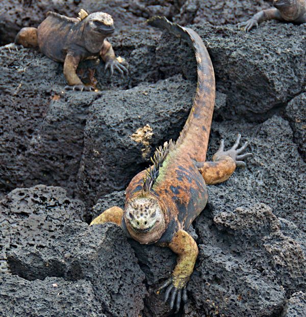
Iguana on Santa Cruz Island, Channel Islands National Park. Photo courtesy of A. Davey via Flickr
Santa Cruz is the largest of the Channel Islands, off the coast of Southern California.
According to legend, Santa Cruz Island was named for a priest’s staff accidentally left on the island during the Portola expedition of 1769.
A Chumash Indian found the cross-tipped stave and returned it to the priest. The Spaniards were so impressed that they called this island of friendly people “La Isla de Santa Cruz,” the Island of the Sacred Cross.
Today the protection and preservation of Santa Cruz Island is divided between The Nature Conservancy and the National Park Service. The Nature Conservancy owns and manages the western 76 percent of the island, while the eastern 24 percent is owned and managed by the National Park Service.
In its vastness and variety of flora, fauna, and geology, Santa Cruz Island resembles a miniature California. At over 96 square miles in size and the largest island in California, Santa Cruz contains two rugged mountain ranges; the highest peaks on the islands (rising above 2,000 feet); a large central valley/fault system; deep canyons with year-round springs and streams; and 77 miles of craggy coastline cliffs, giant sea caves, pristine tidepools, and expansive beaches.
One of the largest and deepest sea caves in the world, Painted Cave, is found on the northwest coastline of Santa Cruz. Named because of its colorful rock types, lichens, and algae, Painted Cave is nearly a quarter mile long and 100 feet wide, with an entrance ceiling of 160 feet and a waterfall over the entrance in the spring.
These varied landforms support more than 600 plant species in 10 different plant communities, from marshes and grasslands to chaparral and pine forests. There are 140 landbird and 11 land mammal species; three amphibian and five reptile species; large colonies of nesting seabirds, breeding seals, and sea lions; and other diverse marine animals and plants.
Owing to millions of years of isolation, many distinctive plant and animals species have adapted to the island’s unique environment, including the island scrub-jay and eight plant species found only on Santa Cruz and nowhere else in the world.
The island is also rich in cultural history with over 10,000 years of American Indian habitation and over 150 years of European exploration and ranching.
Santa Cruz Island, known by the Chumash people as Limuw (translates to “in the sea”), was home to ten villages that housed over 1,200 people. Many of these islanders mined extensive chert deposits for making tools and produced “shell-bead money,” used as a major trade item by tribes throughout California.
The largest village on the island as well as on the northern Channel Islands, Swaxil, occupied the area of Scorpion Ranch at the time of Spanish contact (1542).
Large plank canoes, called tomols, provided transportation between the islands and mainland. Remnants of Chumash civilization can still be seen in thousands of shell middens on the island.
Remnants of the ranching era also can be seen throughout the landscape of the island. Adobe ranch houses, barns, blacksmith and saddle shops, wineries, and a chapel all attest to the many uses of Santa Cruz in the 1800s and 1900s.
The National Park Service, along with The Nature Conservancy, has made great efforts to preserve and protect these island resources, including stabilization of cultural sites, rehabilitation of historic buildings, removal of nonnative plants and animals, the recovery of island foxes, reestablishment of bald eagles, and restoration of island wetlands.
All of these efforts have made Santa Cruz Island one of the best places to experience the nationally significant natural and cultural heritage of coastal southern California.
The island has many trails, including around Scorpion Canyon, with opportunities to see the island scrub jays. Scorpion Beach features kelp forests. Smugglers Cove has tide pools. Cavern Point offers Pacific Ocean views and seasonal whale sightings.
Close to the mainland yet worlds apart, Santa Cruz Island is home to plants and animals that are found nowhere else on Earth. The introduction of of non-native, exotic plants and animals have caused the loss of some of these rare species and pushed many others, including the island fox, to the brink of extinction.
In order to save these island species, as well as protect sacred Chumash Native American cultural sites, the National Park Service and The Nature Conservancy embarked upon a multi-year program to help restore balance to Santa Cruz Island’s naturally functioning ecosystems.
Military Uses of Santa Cruz Island
The military forces of the United States took notice of Santa Cruz Island during World War II, and since that time have constructed and maintained strategic installations in the name of national security.
Like all its neighbors, Santa Cruz Island served as an early warning outpost watching for enemy planes and ships during World War II. The Cold War brought the communications station as a part of the Pacific Missile Range. This station remains in operation, although not at the levels of its heyday in the 1950s and 1960s.
Santa Rosa Island
Camping, elk, hunting, surfing, and deer.
Heron on Santa Rosa Island
Channel Islands National Park – Buy this print
Santa Rosa Island is the second largest of the Channel Islands of California at 53,195 acres. Located about 26 miles off the coast of Santa Barbara, California in Santa Barbara County, it includes sandy beaches, grasslands, steep canyons and occasional groves of trees, including the rare Torrey pine grove above Bechers Bay.
Called Wimal by the Chumash, the island’s native inhabitants, Santa Rosa Island has a history of human occupation stretching back at least 13,000 years.
Following the Chumash came European explorers, Chinese abalone fishers, sea mammal hunters and fisherman, as well as ranchers, sport hunters, oil companies and the military, all of them leaving traces of their use of the island
Chumash on Santa Rosa Island and European Contact
Archaeologist Phil Orr’s discovery of human bones in 1959 at Arlington Springs provided evidence of the oldest known habitation of the island. Recently radio-carbon dated to 13,000 years before present, these are among the oldest securely-dated human remains in North America.
The age of the Arlington remains and a host of archeological sites on the Channel Islands that date to the late Holocene (10,000-6,500 years before present) indicate an early migration route from the Old World into North America along the West Coast.
Santa Rosa Island and the other Channel Islands provided rich resources for seafaring peoples to thrive by hunting seabirds, sea mammals, fish and shellfish.
With extensive trade networks on the mainland, the island Chumash were able to trade marine resources with mainland peoples for goods they could not harvest or produce on the island.
With plentiful food and fresh water, the island supported several villages at the time of European contact.
Juan Rodriguez Cabrillo sailed up the coast of California in 1542, the first European to visit the Channel Islands, and documented three villages on Santa Rosa Island. A half-century later, Sebastian Rodriguez Cermeño wrote about his interaction with the Chumash on the south side of the island on December 13, 1595, as he sailed southward along the coast:
…and there came alongside a small boat like a canoe, with two Indians in it rowing. And having arrived at the launch, they brought some eighteen fish and a seal and gave them to us, for which we gave them some pieces of taffeta and cotton cloth in order that they should bring more. They went on shore and returned in the same boat with three Indians and brought nothing, At this island we went fishing with lines and caught some thirty fishlike cabrillas [sea bass], which we soon ate on account of our great hunger….On both [Santa Rosa Island and Santa Cruz Island] the land is bare and sterile, although inhabited by Indians, there are no ports or coves in them in which to take shelter.
Maritime Commerce
Following the removal of the Chumash from the island, there were no permanent island residents for the next twenty years. Passing mariners, fishermen and otter hunters visited Santa Rosa Island to exploit its marine resources.
Desires for fine furs in China and Europe encouraged otter hunting along the Pacific coast in the late 1700s and early 1800s. English, Russian and American companies exploited this trade, employing Aleut and Hawaiian hunters to slaughter the animals.
George Nidever, an American otter hunter, used a cave on the island at Bechers Bay as a headquarters for his two recorded hunting expeditions on the island. On his second trip Nidever and his crew collected sixty otter skins, but encountered armed conflict on the island.
Nidever tells a legendary story of being victorious after an attack by a group of otter-hunting northwestern Indians working for an English company while he and his crew were hunting at Santa Rosa Island.
Introduction of Ranching
Mexico gained its independence from Spain in 1821, coming into possession of Alta California and the Channel Islands. In 1838, in response to the foreign otter hunting depredations, the government ordered the distribution of land grants to Mexican citizens to prevent incursions by foreign interests.
This resulted in the grant of Santa Rosa Island to the Carrillo brothers, who were prominent residents of Santa Barbara. In October of 1843 Jose Antonio and Carlos Barrelo Carrillo gained ownership of the island but ended up selling it a month later.
The Carrillo brothers sold the island to Carlos’ married daughters and their husbands, Alpheus Thompson and John C. Jones, who had engaged in the otter trade and other entrepreneurial endeavors along the coast.
According to the land grant, improvements had to be made on the island in order to maintain possession. Consequently, in December of 1843 Thompson had materials shipped to the island for a house and corrals, which were built in 1844.
The first structures on the island were located between Skunk Point and East Point in an area now called Rancho Viejo or “Old Ranch.”
Thompson and Jones brought the first livestock to the island in 1844: 270 head of cattle, 51 ewes, two rams, and nine horses. Thompson’s employees took up residence on the island and supervised the grazing cattle, sheep and horses.
During the following decade, numerous livestock, horseback and wagon trails were developed across the island.
In 1855 the owners constructed a house and corral at Bechers Bay, which was more reliable for shipping conditions and provided more level land for ranching and agricultural activities.
Drought and litigation between the two partners over control of the island led to the removal of most of the cattle and sheep by 1859.
The More Era
In 1859, T. Wallace More purchased part of Jones’s interest in Santa Rosa Island. That year, spurred by drought and litigation between the partners over control of the island, most of the sheep and cattle were removed from the island. More and two of his brothers began purchasing Thompson’s shares in the island ranch until A.P. More acquired the last of the shares in 1870.
Following a disastrous drought that devastated California’s cattle industry during 1863-1864, the Mores commenced development of a huge sheep ranch on the island, eventually owning between 40,000 and 80,000 head.
They erected miles of redwood fences and planted crops. The Mores abandoned the East Point ranch site, developing their headquarters at Bechers Bay. By 1873, they had constructed a wharf at Bechers Bay, a two-story house and barns at the ranch site. They reported that 40,000 sheep were sheared that year.
As a result of a severe drought in 1876-78, the Mores were forced to slaughter tens of thousands of sheep, but managed to profit from the situation by installing two large boilers in one of the barns, which were used to render the carcasses for fat.
The Santa Barbara Press reported on the matanzas (killings) saying that “25,000 sheep are to be killed, which will leave from 15,000 to 20,000 on the island. The matanza works erected by the firm are said to be among the largest and most complete on the coast.”
A.P. More acquired full interest in the island in 1881 and continued to increase the number of sheep on the island. A contemporary writer claimed that 80,000 sheep grazed on the island in 1888.
During an 1892 visit to the island, a reporter from Overland Monthly described the island’s shearing operations. He noted that sheep at the More ranch were clipped by about forty seasonal shearers who bunked in the loft of the horse barn.
During the shearing process, each shearer would place his fleece on a table to be collected and call out his tally number. An experienced shearer could produce up to 100 fleeces every day.
The death of A.P. More in 1893 led to litigation and the eventual sale of Santa Rosa Island. More’s heirs began to sell their shares to Vail & Vickers Co. in 1901. By 1902 Vail & Vickers owned the entire island.
The Vail & Vickers Ranch
Walter L. Vail and J.V. Vickers were both prominent cattle ranchers in Arizona. By the turn of the century, they had developed a partnership and expanded their operations to southern California. Vail & Vickers began introducing more cattle to Santa Rosa Island while removing the sheep, running a large “stocker” operation where young cattle were brought to feed on the island grass for one or two years, and then sold to buyers on the mainland.
The ranch headquarters in Bechers Bay comprised the ranch house, bunkhouse and two barns, dating to the 1860s or ’70s. A small schoolhouse and other outbuildings were added in the 1900s.
Vail & Vickers purchased a new boat, repaired buildings and fences, and built additional fences and corrals.
They used the old sheep pasture divisions, enhancing them for cattle use and avoided overgrazing by moving the cattle from pasture to pasture and regulating numbers according to the amount of available feed and water.
All pastures, roundups and perennial streams were identified by name, most of which were place names that carried over from the nineteenth century.
Vail & Vickers stocked the island on a double season strategy, giving cattle two full feed seasons for growth. Depending on the season and forage quality, between 3,000 and 7,000 head of cattle grazed on the island at any given time.
Round-up corrals were located at Arlington, Las Cruces and China Camp by 1929. Vail & Vickers owned the cattle boat Vaquero to transport their cattle to and from the island. When the government confiscated the boat for use in World War II, Vail & Vickers replaced her with the Vaquero II in 1959.
The boats were equipped with pens to hold the cattle and the island pier had a loading chute allowing the cattle to be loaded and unloaded on the boat. Cattle leaving the island were held in the ranch corrals at the head of the pier and were run down the pier and loaded onto the boat before sunrise.
Vail & Vickers did not develop many roads on the island until the late 1940s. Ranch superintendent C. W. Smith blasted out a road along a cattle trail into the steep canyons on the north side of the island during the 1920s and 30s.
Oil companies constructed roads in 1932 and the 1940s for exploratory drilling. The military built roads during the 1950s.
Members of the Vail family managed the ranch operations from Los Angeles and later Santa Barbara, and regularly visited the island.
After Walter Vail’s death in 1906, his son N.R. managed the ranch. In 1943 N.R.’s brother Edward took over management until 1962, when his nephew Al succeeded him.
Al Vail, the third generation of Vails to manage the ranch, continued ranch operations until the ranch shut down in 1998. The Vail & Vickers cattle operation ended in 1998 with the removal of the last herds of cattle, nearly 100 years after they purchased the island ranch.
Other Uses of Santa Rosa Island
The Vails began importing deer and elk to the island for sport hunting around 1910, although there are accounts of deer and elk on the island prior to that date. Elk were reportedly shipped from the San Joaquin Valley, Yellowstone National Park, and the Rocky Mountains.
Deer were introduced in 1929 and came from several sources, primarily the Kaibab National Forest. Until the 1970s, hunting was primarily done by the cowboys, Vail & Vickers family members, friends and guests, and included active efforts to rid the island of the feral pig population.
Commercial hunting began in 1977 and ended in 2011 with the end of the Vail’s reservation of use and occupancy on the island.
When the Santa Barbara area was discovered to be a rich source of oil, oil companies sought to drill exploratory wells on the islands. Standard Oil Company developed a well in the high elevations of the island in 1932, but was unsuccessful.
Signal Oil and its partners also drilled for oil in a number of locations and were not successful. The oil companies constructed roads to their wells that became important routes on the island in later days.
After the United States joined World War II, the military negotiated a lease with Vail & Vickers in 1943 to set up an early warning radar facility on the south side of the island.
The Army Corps of Engineers built a radar system at a location now called Signal Hill and a cantonment about three miles away. The site was closed as the war ended and the buildings and materials were left to be used by the ranch.
As a consequence of the Cold War, in 1950 the Air Force leased 336 acres on the south side of the island to house the 669th Aircraft Control and Warning Squadron. They constructed an advanced technical outpost on a high peak and established a residential, maintenance and administrative area for over 200 personnel, along with a pier, at Johnson’s Lee.
The Navy added missile-tracking facilities on Navy Hill in 1952. The Air Force base closed in 1963 when advancing technology made it redundant. The buildings and materials again were left for the use of the ranch, which made use of the guardrails for corral construction and windows, doors and building materials for new buildings around the ranch.
Channel Islands National Park
Legislation creating Channel Islands National Park in 1980 expanded the boundaries of the 1938 National Monument to encompass Santa Rosa, Santa Cruz and San Miguel islands.
In December 1986, the National Park Service purchased the island from Vail and Vickers. Vail & Vickers retained a twenty-five year reservation of use and occupancy of about seven acres in Bechers Bay and negotiated a special use permit to continue their cattle ranching and commercial deer and elk hunting on the island.
The Park Service set up its island operations at Johnson’s Lee and began improvements to the island’s water and wastewater systems. The park established a campground, constructed a generator facility and photovoltaic system, improved the pier at Bechers Bay and opened the island to visitor use.
In the mid-1990s the park moved its operations to the ranch area and constructed park housing and a maintenance facility on a hill above Bechers Bay.
Cattle ranching ended on Santa Rosa Island with the last of the cattle being shipped to the mainland in 1998. The twenty-five-year use and occupancy reservation expired in 2011, leaving the entire island under the management of the National Park Service.
Approximately 5,000 visitors come to Santa Rosa Island each year to explore the world of the native Chumash, walk the shores where European explorers landed, visit the island ranch complex, and see coastal California as it might have been hundreds of years ago.
Water Canyon Beach, Bechers Bay, Black Mountain, Soledad Peak, and Southeast Anchorage are popular destinations on Santa Rosa.
San Miguel Island
Thousands of seals gather at San Miguel Island’s Point Bennett.
Seals at Point Bennet, San Miguel Island. Photo courtesy of Michael Field via Flickr
Juan Rodriguez Cabrillo and his Spanish fleet first came upon San Miguel Island in 1542. In the waters of the Santa Barbara Channel they found an island chain with a long and rich history.
The Chumash, who lived on the northern islands and along the coastline, had inhabited those lands for millenia, living off of the rich resources of the land and the sea.
Cabrillo’s fleet explored the California mainland and the offshore islands, producing the first accounts of Chumash culture and securing these ancient lands for the Spanish crown.
In time, the four northern Channel Islands of Tuqan, Wi’ma, Limuw, and Anyapakh, as they were known by the Chumash, were given their present names (San Miguel, Santa Rosa, Santa Cruz, and Anacapa).
Over the centuries, the islands saw several economic transformations. The Chumash food sources and trading patterns with the mainland were disrupted by European newcomers’ otter and seal hunting, fishing, shellfish harvesting, and kelp production which were some of the earliest European industries to develop among the Channel Islands.
By the first quarter of the 19th century, the Chumash had vacated the islands to take up residence on the mainland, primarily in the Catholic missions established by the Spanish along the California coastline.
Mexican independence from Spain and California statehood saw a shift towards livestock ranching. Each of the five park islands supported sheep grazing during the early 20th century.
Santa Rosa Island and Santa Cruz Island both had large cattle operations. World War II coastal defenses and the Cold War build-up both left remnants of their presence of the islands.
The remains of numerous shipwrecks testify to the hazards the islands posed to California’s busy mariners as they navigated the narrow channel.
In 1932, the U.S. Coast Guard constructed a light station on Anacapa Island, whose lighthouse and fog signal are still in operation today.
On April 26, 1938, President Franklin D. Roosevelt established Anacapa and Santa Barbara islands as the Channel Islands National Monument. The Monument was later enlarged to include the one-mile area around the islands which brought the offshore kelp beds and marine life under park protection.
The present Channel Islands National Park, which was created in 1980, includes the five islands of Anacapa, Santa Cruz, Santa Rosa, Santa Barbara, and San Miguel.
Santa Barbara Island
Southernmost Santa Barbara Island draws nesting seabirds.
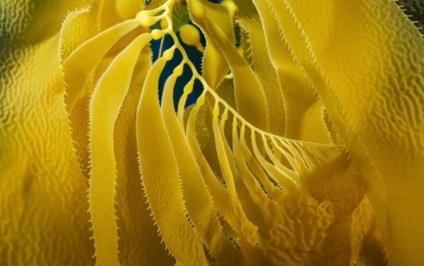
A forest of giant kelp (Macrocystis pyrifera), off Santa Barbara Island – Buy this print
The smallest of the Channel Islands, Santa Barbara Island is about thirty-eight miles from the mainland and is centrally located in relation to all eight of the offshore islands.
Surrounded by sheer cliffs on all sides, the island sits alone in the sea with only little Sutil Islet and Shag Rock to the southwest and northeast respectively to keep it company. Few beaches are found on the island, and those that are prove to be rocky and often treacherous to reach.
The island has a pastoral quality with rolling slopes and a wide saddle between twin peaks, the taller of the two reaching 634 feet. Santa Barbara Island is home to native seabird colonies, barking sea lions, and a rich cultural history.
Native Occupation and European Contact
Due to the lack of fresh water and few terrestrial resources, Santa Barbara Island most likely did not support any permanent native settlements. Recent studies show evidence that occupation of the island dates back at least 4,000 years, suggesting seasonal visits to the island.
Southern California Indians would have been drawn to the island by the rich marine life surrounding the rocky shores, being able to fish, harvest shellfish and hunt pinnipeds, as well as manufacture tools.
Since early European explorers did not leave any indication of landing on the island, no information about native island use or occupancy of the island has come from those sources. Although the explorers did see the small island, it did not receive much documentation.
Cabrillo’s chroniclers dubbed the southern islands, which included Santa Barbara, the “other islands of San Lucas.” Sebastian Vizcaino gave the island its name in honor of the saint whose day was December 4, the day he arrived, in 1602.
Early History
Santa Barbara Island came into the possession of the United States in 1848 and has continued in U.S. government ownership since that time. Early government surveys done in 1853 and 1871 provided a topographic map of the island and Signal Peak was given its name when a triangulation signal was used at its highest point.
While no leases were recorded on the island prior to 1909, people did periodically occupy the island. InThe Land ofSunshine, published in 1897, author J. R. Britton compared the island’s profile to that of a camel; he wrote that “upon the higher hump stands the decaying beacon of the U. S. Coast Survey.”
He also noted “a narrow shelf where a crayfisherman has built a hut of lath and canvas.”
Fisherman and hunter Heman Bay Webster lived on Santa Barbara Island as a squatter in the 1890s. He built a cabin in 1896 near the arch on the island’s northwest point that now bears his name, Webster Point.
In a 1940 interview, he recalled “abundant” cats living on the island until disease diminished their numbers. Webster was at home with the elements, going barefoot and having interests in other islands, mainly Anacapa where he ran sheep.
Other men made Santa Barbara Island a regular port around the turn of the century as well. Buster Hyder recalled that Carl Jergensen and Bert Johnson spent years fishing for lobsters at Gull Rock (Sutil Island) in Thor, a boat built by Hyder’s father.
The U.S. Department of Commerce and Labor began leasing the island for agricultural and recreation purposes in 1900, advertising the island for a five-year lease in newspapers along the coast. J.G. Howland, being the highest bidder, obtained the first recorded lease of Santa Barbara Island on July 6, 1909.
Soon after, Howland sublet the island to C.B. Linton for the purpose of propagating pearls in abalone. After five years, Howland did not renew his lease on the island.
The Hyder Family
In the spring of 1914, public notices were again posted for a five year lease of Santa Barbara Island. Two bids were received, T.D. Webster of Carpinteria and Alvin Hyder of San Pedro; Hyder made the higher bid of $250 a year and acquired the lease on June 16, 1914.
The largest settlement of people on the island in historic times moved onto the island with Hyder. At one time around 1915, about fifteen people lived on the little island including Alvin’s wife Nora and son Denton O., “Buster”, as well as his two brothers and their wives.
The year prior to the families’ arrival, Hyder and his brothers had built a house near the edge of the island 100 yards south of and 150 feet above the landing. They anchored the house to the ground by cables so the wind would not blow it off the cliff.
Hyder rebuilt the pier at the landing, where supplies and equipment were unloaded with a boom. To provide relief from carrying goods up and down 150 feet, he rigged a sled on wood tracks down the steep slope between the landing and the house.
Since the island had no springs or flowing water, the Hyders constructed a system of reservoirs. They built two large concrete cisterns at the house and brought water on Nora II from the mainland.
In 1918 they installed a Rambler auto engine to pump the water to the house from the landing. They searched the island for water sources, even looking for fresh water deep in sea caves, with no luck.
Any collecting methods possible were used, no matter how disgusting. Buster recalled how “you had to limit your drinking water. It had to last a year. Then it got stagnant. Many times when it was raining I’d drink water out of horse tracks. No kiddin’.”
Buster had the job of removing dead mice from the drinking water supply every day. “Boy, it was hard to drink it. But when you don’t have anything else, you have to drink it.”
In the early decades of the century, people made good money raising rabbits, marketing the meat and selling the pelts.
Following the trend, the Hyders brought hundreds of pure black and pure white Belgian hares out to the island and turned them loose. They also brought about 300 sheep to the island in 1915, the first known sheep to graze there, where they would be fattened and sold for meat.
The Hyders also had two horses, Dan and Charlie, and two mules, Jack and Beck, which they kept in a barn they built. Along with these animals, the Hyders also kept goats, pigs, chickens, turkeys and geese on the island.
The Hyder lease expired in 1919 but they stayed on anyway. After seven years of hard work and frustration, they decided to leave the island in 1922. They took their twelve goats, 300 sheep, dogs and four horses to their homestead in Cuyama Valley north of Santa Barbara.
Following the terms of the lease, they tore down the buildings and brought the materials to the mainland, although they failed to remove the main house. Reportedly Alvin Hyder tried to lease Santa Barbara Island for another term without success; an entrepreneur from Venice outbid him.
Nevertheless, he took 250 sheep back to the island for fattening many years after their lease had run out.
Government Activities on Santa Barbara Island
After the Hyders left the island, several attempts to lease and build resorts were made, but none succeeded. No major improvements were made to the island until the government built lighthouses.
As early as 1853 government officers made note of the potential of Santa Barbara Island for lighthouse purposes. However, it would take 75 years to get a navigational aid built on Santa Barbara Island.
On July 27, 1928, the Bureau of Lighthouses authorized an automatic light on the northerly point of the island “for the protection of inter-island navigation in general and particularly for the protection of the Hawaiian Island and trans-Pacific traffic, which follows a course passing six miles to the northward of the island.”
In 1934, a second light tower went up on the south end of the island, on the westerly side, located 486 feet above the water and visible for twelve miles.
When Santa Barbara Island became part of the Channel Islands National Monument in 1938, two parcels of land and right of entry were retained for by the government for lighthouse purposes.
In April 1936, the Commandant of the 11th Naval District requested permission to install and maintain a range finder marker on Santa Barbara Island. The Navy built a tower about ninety feet tall at the highest point on the island, 634-foot Signal Peak, which was probably removed by 1942 when the Army Signal Corps installed radar on the island.
At the outbreak of World War II, the military ordered both lights to be temporarily extinguished. They were relit in 1943 when the immediate threat to Los Angeles Harbor was felt to be over.
During the war, the Navy took over responsibility for U. S. Coast Guard activities, including aids to navigation, and instituted a program of timed blackouts of coastal lights in case of enemy attack.
The Navy also set up Coastal Lookout Stations on the island to help prevent attacks on the mainland.
Santa Barbara Island and Channel Islands National Monument
As early as 1932, the Bureau of Lighthouses suggested transferring Santa Barbara Island, as well as Anacapa Island, to the National Park Service for preservation. Not until 1938 did the National Park Service respond, and on April 26, the island became part of the newly designated Channel Islands National Monument, encompassing Anacapa and Santa Barbara islands.
On June 28, 1939 NPS biologists E. Lowell Sumner, Jr. and R. M. Bond submitted a report on the biology of the islands suggesting protection of the island by the Coast Guard and State Division of Fish and Game, as well as posting signs in order to alert visitors of the island’s new Monument status.
In 1949 the monument boundaries were expanded to include “the area within one (1) nautical mile of the shoreline of Anacapa and Santa Barbara Islands.” On Santa Barbara Island, this meant that the rocky beaches, offshore rocks and Sutil Island and Shag Rock would be protected.
The Channel Islands National Monument was moved from the supervision by Sequoia National Park to be overseen by Cabrillo National Monument in San Diego in 1957.
Rabbits and vandalism became major problems on the isolated island, but by the time it became part of the Channel Islands National Park in 1980, the rabbits were gone and vandalism was declining.
To help develop the island for visitor use, the National Park Service constructed a new dock and ranger residence on the island in 1991.
Extensive habitat restoration efforts have been underway on Santa Barbara Island to increase the native plant and bird populations which were destroyed after years of rabbit and sheep grazing.
Today, visitors can camp, hike trails covering the whole island, snorkel and kayak to see the beautiful natural environment this small, remote island has to offer.