Great Dismal Swamp National Wildlife Refuge
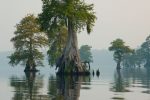
The Great Dismal Swamp National Wildlife Refuge was created in 1973 when the Union Camp Corporation of Franklin, Virginia, donated 49,100 acres (199 km2) of land to The Nature Conservancy, which the following year transferred the property to the U.S. Fish and Wildlife Service. Great Dismal Swamp National Wildlife Refuge »»
Indian Bayou State Wildlife Area
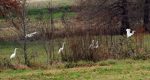
Indian Bayou State Wildlife Area is a cultural feature park in Sharkey County, in Western Mississippi. Indian Bayou State Wildlife Area »»
Black Fork Mountain Wilderness
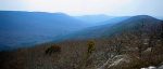
Black Fork Mountain Wilderness contains the rugged ridge of Black Fork Mountain, which is 13 miles long. It was designated by the United States Congress in 1984 and contains a total of 13,347 acres. Most of the land is in Arkansas, but some of the mountain ridge extends into Oklahoma. Black Fork Mountain Wilderness »»
Dugger Mountain Wilderness Area
Designated in 1999, the 9,200 acres of Dugger Mountain Wilderness are in Talladega National Forest in eastern Alabama. At 2,140′, Dugger Mountain is the second highest peak in Alabama. This area is so rugged that the forest is virgin growth: the hills were too steep for the timber to be harvested. Dugger Mountain Wilderness Area »»
Joshua Tree National Park

Two distinct desert ecosystems, the Mojave and the Colorado, come together in Joshua Tree National Park. A fascinating variety of plants and animals make their homes in a land sculpted by strong winds and occasional torrents of rain.
Dark night skies, a rich cultural history, and surreal geologic features add to the wonder of this vast wilderness in southern California. Joshua Tree National Park »»
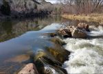
Five tips for the best techniques for skipping stones

What better way to enjoy a lazy, late summer afternoon than combing the beach for the perfect rock—flat, round, light enough to fly, heavy enough to go the distance. Snap it just so, and watch it leap across the surface. Learn the best techniques and the best Washington lakes to do it on here. Five tips for the best techniques for skipping stones »»
Sites and Trails in Northern Death Valley National Park
Northern Death Valley National Park is a lonelier, less visited section of the valley but equally scenic as the south. Higher in elevation; sloping up to 3,000 feet at Scotty’s Castle.
Sites and Trails in Northern Death Valley National Park »»
Sites and Trails in Southern Death Valley

The South is the most visited section of Death Valley, incuding Artist’s Palette, Badwater, Dante’s View, Devil’s Golf Course and Zabriskie Point. Sites and Trails in Southern Death Valley »»
Death Valley National Park
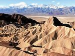
A world of extremes, Death Valley National Park is the nation’s driest, hottest and lowest place, but also features mountains over 11,000 feet high that experience below-zero weather and snow, as well as colorful badlands, sand dunes and canyons. Its dramatic mountains, valleys and a world of extremes.
Death Valley is the nation’s driest, hottest and lowest place, but also features mountains over 11,000 feet high that experience below-zero weather and snow, as well as colorful badlands, sand dunes and canyons. Death Valley National Park »»
Encampment River Wilderness Area
In the northernmost extension of the Southern Rocky Mountains, the Encampment River flows north out of Colorado, past the town of Encampment and into the North Platte River. Along part of the river’s canyon lies Wyoming’s smallest Wilderness, approximately 16 square miles, a strip less than one mile wide in the southern portion that widens to about five miles near the northern boundary. This is known as the Encampment River Wilderness Area. Encampment River Wilderness Area »»
Channel Islands National Park

Channel Islands National Park is made up of five ecologically rich islands off the Southern California coast and their surrounding one mile of the ocean.
Accessible by boat or plane, the Channel Islands are rarely crowded, but peak times are June–August. The climate is mild year-round.
Swimming, snorkeling, diving, kayaking and whale-watching (blue and humpback) are common activities June–September. Channel Islands National Park »»
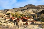
Hot Springs National Park
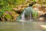
Hot Springs National Park is a unique combination of urban and natural landscapes. The hot springs themselves are in the area known as Bathhouse Row in the heart of downtown Hot Springs, Arkansas, and visitors can still take a traditional bath in several of the bathhouses.
Visitors can also hike on 26 miles of trails, camp near Gulpha Creek, or stroll the historic district and enjoy drinking from the water fountains that are fed by the natural springs. Hot Springs National Park »»
Petrified Forest National Park

The only national park in the U.S. to contain a portion of the famous and historic Route 66 is Petrified Forest National Park. Petrified Forest National Park »»
Saguaro National Park
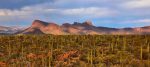
Saguaro National Park is named after the giant saguaro cactus forest, unique to the Sonoran desert. It is the only national forest in the US made up entirely of giant cactus plants. But, for me, the real highlight is the ancient petroglyphs at Signal Hill. Saguaro National Park »»
Grand Canyon National Park

Although first afforded Federal protection in 1893 as a Forest Reserve and later as a National Monument, the Grand Canyon did not achieve National Park status until 1919, three years after the creation of the National Park Service. Today Grand Canyon National Park receives close to five million visitors each year. Grand Canyon National Park »»
Agua Tibia Wilderness
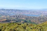
The Agua Tibia Wilderness is in Riverside and San Diego counties, California. It is mostly within the Palomar Ranger District of the Cleveland National Forest.
Agua Tibia Wilderness »»
Wrangell-St. Elias National Park

Even in a state famous for its size, Wrangell-St. Elias National Park stands out. It is by far the largest of our national parks—almost six times the size of Yellowstone.
Four major mountain ranges converge here: the volcanic Wrangells, the Alaska, the Chugach, and the St. Elias—tallest coastal mountains in the world. Together they contain 9 of the 16 highest peaks in the United States, 4 of them above 16,000 feet.
You fly over it and see mountains beyond mountains, glaciers after glaciers, rivers upon rivers. You float a river and watch the moods and mountains change by the minute. As you walk the tundra, you find Dall’s sheep and mountain goats grazing. Wrangell-St. Elias National Park »»
Caribou-Speckled Mountain Wilderness
Caribou-Speckled Mountain Wilderness is 11,233-acres located within the White Mountain National Forest in western Maine. It is Maine’s largest wilderness area. The property is centered around Speckled Mountain and Caribou Mountain, separated from each other by about four miles of rugged and heavily-forested countryside. Caribou-Speckled Mountain Wilderness »»
Winter is a great time to bird watch at state parks in Puget Sound and the Strait of Juan de Fuca
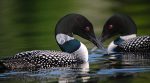
Winter is a great time to break out the binoculars and check out the bird action at state parks in Puget Sound and the Strait of Juan de Fuca. Many Washington state parks are a sanctuary for migratory and year-round bird populations. Cold, clear days on the Olympic Peninsula draw all kinds of fowl to the water. So gather your camera and binoculars and let’s shake a tailfeather! Winter is a great time to bird watch at state parks in Puget Sound and the Strait of Juan de Fuca »»
Lake Clark National Park
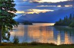
Lake Clark National Park and Preserve is a United States National Park in Port Alsworth, Alaska. It was first proclaimed a national monument in 1978, then established as a national park and preserve in 1980 by the Alaska National Interest Lands Conservation Act.
About two-thirds was designated wilderness. While both sport and subsistence hunting are permitted in the national preserve lands, only subsistence hunting by local residents is permitted within the national park.
The park includes many streams and lakes vital to the Bristol Bay salmon fishery, including its namesake Lake Clark. Lake Clark National Park »»
International Wilderness Leadership School

The International Wilderness Leadership School is a division of Alaska Mountain Guides and Climbing School, Inc. No other leadership organization has the technical background, scope of programming, and the hands on leadership and guiding experience of IWLS. International Wilderness Leadership School »»
Kobuk Valley National Park
Far from the hustle and bustle of other Alaskan destinations, the untamed nature of Kobuk Valley National Park allows you to experience “Wild Alaska” on its own terms.
There are many possibilities for adventure. You can boat down the languid Kobuk River, feel the thrill of a bush airplane flight, or chart your own backcountry trip. Kobuk Valley National Park »»
Eight Common Mistakes of Wilderness Survival

Most Wilderness Survival situations start off very innocent; like a fishing trip with friends, a day hike emergency preparedness risk on a familiar trail, or a planned father & son hunting trip. Then things go terribly wrong and suddenly you are faced with a life and death scenario. Learn the most common mistakes of wilderness survival that can take your life. Eight Common Mistakes of Wilderness Survival »»
Kenai Fjords National Park

At the edge of the Kenai Peninsula lies Kenai Fjords National Park, a land where the ice age lingers. Nearly 40 glaciers flow from the Harding Icefield, Kenai Fjords‘ crowning feature. Wildlife thrives in icy waters and lush forests around this vast expanse of ice where Sugpiaq people have relied on these resources to nurture a life entwined with the sea. Kenai Fjords National Park »»
Katmai National Park and Preserve

Located in the vast, remote southwest corner of Alaska, Katmai National Park and Preserve is famous for volcanoes and the bears which embody the wild heart of Katmai. Within the borders of the national park and preserve are 15 volcanoes, some of them still steaming, and North America’s largest population of protected brown bears—about 2,000 of them.
Up to 50 bears can be spotted at Brook Falls and alongside the river during peak salmon runs, and the Park Service estimates between 80 to 100 brown bears gather just in the square mile centered on the river! Katmai National Park and Preserve »»
Virgin Islands National Park
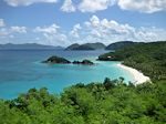
The hills, valleys and beaches of Virgin Islands National Park are breathtaking. It covers approximately 60% of the island of Saint John in the United States Virgin Islands, over 5,500 acres of adjacent ocean, plus nearly all of Hassel Island, just off the Charlotte Amalie, Saint Thomas harbor. Virgin Islands National Park »»
Gates of the Arctic National Park and Preserve
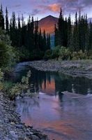
At Gates of the Arctic National Park and Preserve in Alaska, wild rivers meander through glacier-carved valleys, caribou migrate along age-old trails and endless summer light fades into aurora-lit night skies of winter. Gates of the Arctic National Park and Preserve »»
Does every state have a national park?
Technically, not every state has a national park. There are twenty-three states who have no designated National Park, and the District of Columbia also does not have a national park. Does every state have a national park? »»
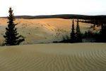
Denali National Park
Denali National Park contains 6 million acres of wilderness — with only one road! Travelers along it see the relatively low-elevation taiga forest give way to high alpine tundra and snowy mountains, culminating in North America’s tallest peak, 20,320′ Mount McKinley. Denali National Park »»
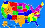
List of National Parks by State
As of the 2010 US Census, the United States has 58 protected areas known as U.S. National Parks, including two in US Territories. Not all states have a US National Park, and some states have several. Here is a list of national parks by state. List of National Parks by State »»
Alphabetical List of US National Parks
An alphabetical list of US National Parks with a brief overview and sample picture. Alphabetical List of US National Parks »»