
Crater Lake National Park
Established in 1902, Crater Lake National Park is the fifth oldest national park in the United States and the only national park in Oregon. The park encompasses the caldera of Crater Lake, a remnant of a destroyed volcano, Mount Mazama, and the surrounding hills and forests. This National Park encompasses 183,224 acres (74,148 ha; 286.29 sq mi).
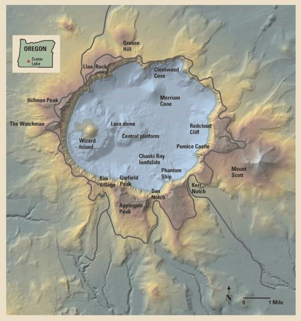 Photo courtesy of USGS, via Wikimedia Commons
The lake is 1,949 feet (594 m) deep at its deepest point, which makes it the deepest lake in the United States, the second deepest in North America and the ninth deepest in the world. However, when comparing its average depth of 1,148 feet (350 m) to the average depth of other deep lakes, Crater Lake becomes the deepest in the Western Hemisphere and the third deepest in the world.
The caldera rim ranges in elevation from 7,000 to 8,000 feet (2,100 to 2,400 m). The United States Geological Survey benchmarked elevation of the lake surface itself is 6,178 feet (1,883 m).
Crater Lake has no streams flowing into or out of it. All water that enters the lake is eventually lost from evaporation or subsurface seepage. The lake’s water commonly has a striking blue hue, and the lake is re-filled entirely from direct precipitation in the form of snow and rain.
History of Crater Lake and the Cascade Range
Volcanic activity in this area is fed by subduction off the coast of Oregon as the Juan de Fuca Plate slips below the North American Plate. Heat and compression generated by this movement has created a mountain chain topped by a series of volcanoes, which together are called the Cascade Range.
The large volcanoes in the range are called the High Cascades. However, there are many other volcanoes in the range as well, most of which are much smaller.
About 400,000 years ago, Mount Mazama began its existence in much the same way as the other mountains of the High Cascades, as overlapping shield volcanoes.
Over time, alternating layers of lava flows and pyroclastic flows built Mazama’s overlapping cones until it reached about 11,000 feet (3,400 m) in height.
As the young stratovolcano grew, many smaller volcanoes and volcanic vents were built in the area of the park and just outside what are now the park’s borders. Chief among these were cinder cones.
Although the early examples are gone—cinder cones erode easily—there are at least 13 much younger cinder cones in the park, and at least another 11 or so outside its borders, that still retain their distinctive cinder cone appearance.
There continues to be debate as to whether these minor volcanoes and vents were parasitic to Mazama’s magma chamber and system or if they were related to background Oregon Cascade volcanism.
After a period of dormancy, Mazama became active again. Then, around 5700 BC, Mazama collapsed into itself during a tremendous volcanic eruption, losing 2,500 to 3,500 feet (760 to 1,070 m) in height.
The eruption formed a large caldera that, depending on the prevailing climate, was filled in about 740 years, forming a beautiful lake with a deep blue hue, known today as Crater Lake.
The eruptive period that decapitated Mazama also laid waste to much of the greater Crater Lake area and deposited ash as far east as the northwest corner of what is now Yellowstone National Park, as far south as central Nevada, and as far north as southern British Columbia. It produced more than 150 times as much ash as the May 18, 1980 eruption of Mount St. Helens.
Climate at Crater Lake National Park

Crater Lake and Wizard Island, Crater Lake National Park- Buy this print
Snow is relatively rare at low elevations in western Oregon, but it is common at higher elevations, especially at Crater Lake. Winter, which typically begins at the park in September and runs through June, includes an average of 98 days with measurable snowfall.
Up to 37 inches (94 cm) of snow have fallen on the park in a single day (in 1937, 1951, and 1971), 313 inches (800 cm) in a month (January 1950), and 903 inches (2,290 cm) in a year (1950).
Snow typically accumulates in the park to depths of 10 to 15 feet (3.0 to 4.6 m) in average years. Most of the park’s roads remain closed through late spring, and snow lingers into the summer. In July and August, snowfall is uncommon.
January is the coldest month, when highs average about 35 °F (2 °C) and lows average about 18 °F (−8 °C). August is the warmest month, with an average high of 69 °F (21 °C) and an average low of about 40 °F (4 °C).
The scenery of Crater Lake is fully accessible during the summer months. Heavy snowfalls in this park during the fall, winter, and spring months force many road and trail closures, including the popular “Rim Drive”, which is generally completely open only from July to October and partially open in some other months, such as May, June, and November.
Although snow covers Crater Lake National Park for eight months of the year, the lake rarely freezes over due in part to a relatively mild onshore flow from the Pacific Ocean. The immense depth of Crater Lake acts as a heat reservoir that absorbs and traps sunlight, maintaining the lake temperature at an average of 55 °F (13 °C) on the surface and 38 °F (3 °C) at the bottom throughout the year.
Mammals that are residents of this national park
This national park is home to Canadian lynxes, bobcats, beavers, chipmunks, pikas, foxes, cougars, squirrels, porcupines, black bears, brown bears, coyotes, timber wolves, badgers, deer, elk, muskrats, and martens.
Birds that commonly fly through this park including raptors are american dippers, peregrine falcons, ravens, Clark’s nutcrackers, gray jays, bald eagles, hummingbirds, spotted owls, and Canada geese.
Notable park features
- The Pumice Desert: A very thick layer of pumice and ash leading away from Mazama in a northerly direction. Even after thousands of years, this area is largely devoid of plants due to excessive porosity and poor soil composed primarily of regolith.
- The Pinnacles: When the very hot ash and pumice came to rest near the volcano, it formed 200-to-300-foot (60 to 90 m) thick gas-charged deposits. For perhaps years afterward, hot gas moved to the surface and slowly cemented ash and pumice together in channels and escaped through fumaroles. Erosion later removed most of the surrounding loose ash and pumice, leaving tall pinnacles and spires.
- Mount Scott is a steep andesitic cone whose lava came from magma from Mazama’s magma chamber; geologists call such volcano a parasitic or satellite cone. Volcanic eruptions apparently ceased on Scott sometime before the end of the Pleistocene; one remaining large cirque on Scott’s northwest side was left unmodified by post-ice age volcanism.
- Union Peak in the southwest corner of the park is an extinct volcano whose primary remains consist of a large volcanic plug, which is lava that solidified in the volcano’s neck.
- Crater Peak is a shield volcano primarily made of andesite and basalt lava flows topped by andesitic and dacite tephra.
- Timber Crater is a shield volcano located in the northeast corner of the park. Like Crater Peak, it is made of basaltic and andesitic lava flows, but unlike Crater, it is topped by two cinder cones.
- Rim Drive is the most popular road in the park; it follows a scenic route around the caldera rim.
- Llao Rock on the north side rises 1,800 feet (550 m) above the lake, with a 1.3-mile (2.1 km) trail from Rim Drive leading to the summit.
- Old-growth forests cover 50,000 acres (20,000 ha).
Hiking Trails
-
The Pacific Crest Trail, a 2,650-mile (4,260 km) long-distance hiking and equestrian trail that stretches from the Mexican to Canadian borders, passes through the park. -
Cleetwood Cove Trail originates on the north side of the lake about 4.5 mi (7.2 km) east of North Junction along East Rim Drive. The trail is the only one that accesses the shoreline of the lake, descending 656 feet (200 m) from the Cleetwood Cove parking lot. First opened during the summer of 1960, the trail is 1.1 miles (1.8 km) long with an 11% grade that rates it as a strenuous route on the return trip. Due to its steep grade, the trail is not accessible for mobility-impaired visitors. A dock with concessionaire boats facilitates tours around the lake with a stop at Wizard Island for dropping off and picking up passengers. Swimming and fishing are permitted. Snow may cover the trail from October to July with some variance depending on yearly snowfall conditions.
-
Watchman Peak Trail begins from the Watchman Overlook parking lot, about 3.8 mi (6.1 km) northwest of Rim VillageThe trail is 0.8 mi (1.3 km) long with a 420 ft (130 m) elevation change. It is a steady uphill trail on an isolated mountain on the west rim of the crater, with several switchbacks, providing wide views of Crater Lake and Wizard Island. Several nearby landmarks are visible from the summit, including Mount McLoughlin, Mount Thielsen, Union Peak, Mount Scott and the Klamath Basin. The trail ends next to a historic fire lookout tower built in 1932.
-
The Lightning Spring Trail starts from the Lightning Spring picnic area. It is a 3⁄4-mile (1.2 km) hike with an elevation gain of 250 feet (76 m). The trail circles around several meadows up to the Lightning Spring creek. The trail is known for the frequent sights of grazing deer.
-
Castle Crest Wildflower Garden is considered to be the easiest trail, looping around the Castle Crest Wildflower Garden. It starts from the East Rim Road, near the park’s headquarters. It received its name because of a large stretch of meadows around which the trail circles and which is bursting with wildflowers in the springtime. The trail is about 1⁄2 mile (800 m) before it reaches the wildflower meadow garden, from which other improvised routes depart.
-
Plaikni Falls Trail is the newest trail on the Crater Lake park. It stretches 1.1 miles (1.8 km) from the trailhead located 1.2 miles (1.9 km) south from the Phantom Ship Overlook on Pinnacles Road, which spins off Rim Drive. The trail leads to the Plaikni Falls. Most of the trail is Wheelchair accessible. The final stretch is fairly uphill, which may prove moderately challenging.
-
Garfield Peak Trail is a moderately challenging 1.7-mile (2.7 km) hike to Garfield Summit. The trailhead is located east of the Crater Lake Lodge and gains approximately 1,000 feet (300 m) of elevation. Several spots along the trail provide viewpoints overlooking the Phantom Ship island and Dutton Cliff. A few viewpoints offer unique views of Wizard island. The trail is popular in the late afternoon on account of unique shifting colors over the lake and its surroundings.

Popular activities in the park

There are many hiking trails and several campgrounds inside the park. Unlicensed fishing is allowed without any limitation of size, species, or number. The lake is believed to have no indigenous fish, but several species of fish were introduced beginning in 1888 until all fish stocking ended in 1941.
Kokanee Salmon (Oncorhynchus nerka) and Rainbow Trout (Oncorhynchus mykiss) now thrive and reproduce here naturally.
Swimming is allowed in the lake, and the boat tours, which stop at Wizard Island, a cinder cone inside the lake, operate daily during the summer.
All lake access for people is from Cleetwood Trail, a steep walking trail, and there are no roads for cars, trucks, or wagons that lead to the waterfront. All of the boats in the lake were delivered by helicopter.
Numerous observation points along the caldera rim for the lake are readily accessible by automobile via the “Rim Drive”, which is 33 miles (53 km) long and has an elevation gain of 3,800 feet (1,200 m).
The highest point in Crater Lake National Park is Mount Scott at 8,929 feet (2,722 m). Getting there requires a fairly steep 2.5-mile (4.0 km) hike from the Rim Drive trailhead.
On a clear day, visibility from the summit exceeds 100 miles (160 km), and one can, in a single view, take in the entire caldera. Also visible from this point are the white-peaked Cascade Range volcanoes to the north, the Columbia River Plateau to the east, and the Western Cascades and the more-distant Klamath Mountains to the west.