Parks by State
- Alabama State Parks
- Alaska State Parks
- Arizona State Parks
- Arkansas State Parks
- California State Parks
- Colorado State Parks
- Connecticut State Parks
- Delaware State Parks
- Florida State Parks
- Georgia State Parks
- Guam Parks
- Hawaii State Parks
- Idaho State Parks
- Illinois State Parks
- Indiana State Parks
- Iowa State Parks
- Kansas State Parks
- Kentucky State Parks
- Louisiana State Parks
- Maine State Parks
- Maryland State Parks
- Massachusettes Parks
- Michigan State Parks
- Minnesota State Parks
- Missouri State Parks
- Mississippi State Parks
- Montana State Parks
- Nebraska State Parks
- Nevada State Parks
- New Hampshire Parks
- New Jersey State Parks
- New Mexico State Parks
- New York State Parks
- North Carolina State Parks
- North Dakota State Parks
- Ohio State Parks
- Oklahoma State Parks
- Pennsylvania State Parks
- Puerto Rico Parks
- Rhode Island State Parks
- South Carolina Parks
- South Dakota State Parks
- Tennessee State Parks
- Texas State Parks
- Utah State Parks
- Vermont State Parks
- Virginia State Parks
- Virgin Islands Parks
- Washington DC Parks
- Washington State Parks
- West Virginia State Parks
- Wisconsin State Parks
- Wyoming State Parks
The vast majority of Southcentral Alaska is on the road system so traveling by car in this region is common. If you drive to Alaska, first remember you will have to go through Canada to get here, so you will need a passport. (more…)
Parks in the State of Alaska
Alaska is the biggest state, has the largest national park, highest peak, longest coastline, and longest day and night. You couldn”t cover even a fraction of this state in a typical one or two week vacation.
The 49th state offers so many things to do and see, you could vacation here for the rest of your life and never have the same experience twice. Alaska’s adventure, history, culture, fishing, hiking, skiing, wildlife watching and scenery just might be the best in all of North America.

Alaska Parks Map courtesy of Google Maps
Alaska is generally divided into five distict regions.
Alaska’s Inside Passage
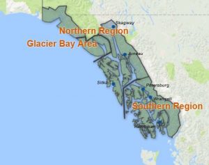
Inside Passage Map
Shaped by the staggering force of massive glaciers millions of years ago, Alaska’s Inside Passage boasts wildlife-filled fjords and lush island scenery — habitat for bald eagles, sea lions, porpoises and whales.
Its mountains are carpeted with majestic forests. Inside Passage Alaska is home to Tlingit, Haida and Tsimshian Indians whose history is reflected in towering totem poles. Russian settlers left a legacy of onion-domed churches gleaming with icons.
The Inside Passage is further sub-divided into the
- Glacier Bay Area
- Northern Region
- Southern Region
South Central Alaska
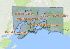
Southcentral Alaska Map
South Central Alaska is home to over half of Alaska’s population. It is a playground of activities from world-class fishing to hiking and wildlife viewing.
With mountains and lakes, Southcentral offers the advantages of remote wilderness, but is linked via roads.
World-class rainbow trout and salmon shimmer brilliantly, beckoning to prospective anglers. Southcentral has the amenities travelers seek, while serving as a gateway to the wilderness experience.
Southcentral Alaska is further sub-divided into:
Southwest Alaska
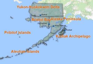
Southwest Alaska Map
In Southwest Alaska brown bears amble along the hills and plains, and more than 240 bird species inhabit Alaska’s Southwest region. The region’s terrain ranges from a landscape of volcanoes in Katmai National Park created by the 1912 eruption of the Novarupta volcano, to the windswept Aleutian Islands that make a 1,000-mile sweep toward Asia.
Southwest Alaska is further sub-divided into:
- Alaska Peninsula
- Aleutian Islands
- Bristol Bay
- Kodiak Archipelago
- Pribilof Islands
- Yukon-Kuskokwim Delta
Interior Alaska

Interior Alaska Map
In Alaska’s heartland, you’ll see the continent’s tallest peak, Denali, and wide expanses of tundra. The forests are teeming with animal and bird life ranging from the formidable grizzly to stately herds of caribou to the state bird, the Willow Ptarmigan.
Experience summer’s midnight sun or the winter’s northern lights. Wildlife can be seen on the highway that runs by Denali National Park, carrying visitors to and from Anchorage and Fairbanks.
Interior Alaska is the original home of Alaska’s Athabascan Indians. Gold miners, farmers and fur trappers later discovered the riches of this region.
Alaska’s interior is further divided into:
- Alaska Highway
- Denali National Park
- Fairbanks
- Northeast Interior
- Western Interior
Alaska’s Far North
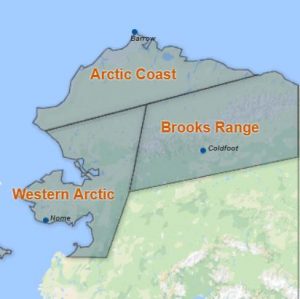
Alaska Far North Map
As Alaska’s visitors cross the Arctic Circle, legend has it that many pilots give the plane a slight “bump” letting passengers know they’ve crossed the legendary circle.
Alaska’s Arctic is home to the Inupiat Eskimos, many whom still live a subsistence lifestyle and still preserve their history verbally from generation to generation.
The Far North is filled with a rich history and natural wonders, from the gold rush days of yore to the Gates of the Arctic National Park and Preserve.
The communities of Alaska’s Far North are accessible from Fairbanks or Anchorage via jet or small aircraft. This is one of Alaska’s most diverse regions, filled with cultural opportunities, wildlife and a landscape ranging from coastal plains to mountain ranges.
The Far North is further sub-divided into:
Alaska’s landscape has an astounding number of parks and public lands that offer outdoor adventures at every turn.
List of Alaska National Parks
- Denali National Park and Preserve
- Gates of the Arctic National Park and Preserve
- Glacier Bay National Park and Preserve
- Katmai National Park and Preserve
- Kenai Fjords National Park
- Kobuk Valley National Park
- Lake Clark National Park and Preserve
- Wrangell-St. Elias National Park and Preserve
Alaska National Rivers
- Alagnak Wild and Scenic River
List of Alaska State Parks and Recreation Areas
This is a List of Alaska State Parks and Recreation Areas in the Alaska state park system, as well as parks designated as recreation Areas. All are run by the Alaska Department of Natural Resources – Division of Parks and Outdoor Recreation.
Anchorage area parks
- Chugach State Park in the foothills near Anchorage, Alaska is the third largest state park in America. Chugach State Park half-million acres of some of the most accessible hiking, skiing, camping, wildlife viewing, snowmachining, rafting, and climbing in Alaska, include clear blue waters at Eklutna Lake, Eagle River, or Bird Creek.
Copper River Basin area parks
- Dry Creek State Recreation Site
- Lake Louise State Recreation Area
- Liberty Falls State Recreation Site
- Porcupine Creek State Recreation Site
- Squirrel Creek State Recreation Site
Interior Alaska parks
Fairbanks area parks
- Birch Lake State Recreation Site is popular with fishermen, jet-skiers, and water skiers in the summer, and with snowmobilers and for ice fishing in the winter. At Birch Lake State Recreation Site, there is excellent fishing all year round for stocked species: rainbow trout, king and silver salmon, grayling, and arctic char. Ice fishing huts are available for rent.
- Chena River State Recreation Area is 397 square miles of forests, rivers, and alpine tundra. Chena River State Recreation Area offers hiking and rock-climbing at Granite Tors. You can harness up the dog team, or perhaps ride a 4-wheeler along a forest trail. The park follows the Chena River, a clear flowing, class I-II river ideal for kayaking, canoeing, or fishing for the abundant arctic grayling. Chena Hot Springs Road parallels the river, providing boaters and anglers many entry and exit points.
- Chena River State Recreation Site (also known as Chena Wayside) is located in Fairbanks on University Avenue. Campsites and picnic sites, as well as restrooms, drinking water, and shelter, are ADA accessible.
- Harding Lake State Recreation Area is 45 miles south of Fairbanks on the Richardson Highway. A boat launch facility gives access to the lake for those having canoes, motorized boats, jet skis or other watercraft.
- Lower Chatanika River State Recreation Area is a 570-acre recreation area near mile 11 of the Elliott Highway.
- Salcha River State Recreation Site
- Upper Chatanika River State Recreation Site
Delta Junction area parks
- Big Delta State Historical Park is located 8 miles north of Delta Junction at Mile 274.5 of the Richardson Highway. Big Delta State Historical Park, Take a walk back into time! The Delta Historical Society maintains a museum in a sod-roofed cabin, the artifacts in the museum, dating from 1900 to 1950, were collected from local people, artifacts include blacksmith tools, horse tack, dog harnesses and sleds, many household items and much more. There is also a display of historic photographs.
- Clearwater State Recreation Site has excellent fishing opportunities for Arctic Grayling, whitefish, and salmon. Clearwater State Recreation Site is reached by turning onto Clearwater Road of the Alaska Highway, or by turning onto Jack Warren Road on Richardson Highway.
- Delta State Recreation Site is a popular campground for those traveling between Tok and Fairbanks. On a clear day one of the tallest mountains of the Alaska Range, Mt. Hayes with an elevation of 13,832 feet, can be viewed from the park.
- Donnelly Creek State Recreation Site is 32 miles south of Delta Junction at mile 238 of the Richardson Highway. Donnelly Creek State Recreation Site is located on the braided Delta River, with views of some of the tallest peaks of the Alaska Range.
- Fielding Lake State Recreation Area
- Quartz Lake State Recreation Area is ten miles north of Delta Junction and is reached by a three-mile road at mile 277.8 of the Richardson Highway. Quartz Lake State Recreation Area is a 600 acre park which often attracts large crowds due to the variety of recreational opportunities available.
Tok area parks
- Eagle Trail State Recreation Site 16 miles south of Tok at mile 109.5 of the Tok Cut-Off Highway. Historical features of the campground include the Valdez-Eagle Trail, the Old Slana Highway, and the Washington-Alaska Military Cable and Telephone System (WAMCATS).
- Moon River State Recreation Site is located 15 miles northwest of Tok. Often called Moon Lake State Recreation Site, it offers a variety of water recreation opportunities.
- Tok River State Recreation Site
Kenai Peninsula area parks
Homer area parks
- Anchor River State Recreation Area
- Deep Creek State Recreation Area is located at mile 137.3 of the Sterling Highway near Ninilchik. The halibut and king salmon runs at Deep Creek are legendary. It is adjacent to the shores of Cook Inlet with excellent scenic views of Mt. Iliamna and Mt. Redoubt. The beaches from Clam Gulch to Ninilchik are the most popular areas for digging razor clams in Alaska.
- Stariski State Recreation Site
- Kachemak Bay State Park was Alaska’s first state park, and only wilderness park. It is joined with Kachemak Bay State Wilderness Park and contains roughly 400,000 acres. Kachemak Bay is a critical habitat area, supporting many species of marine life. Visitors frequently observe sea otters, seals, porpoise and whales. Skiers and hikers will find glaciers and snowfields stretching for miles. Kachemak Bay State Park and State Wilderness Park attractions include Grewingk Glacier, Poot Peak, China Poot Bay, Halibut Cove Lagoon, Humpy Creek, and China Poot (Leisure) Lake.
- Kachemak Bay State Wilderness Park (See above.)
- Ninilchik State Recreation Area is located on the west side of the Kenai Peninsula, about 40 miles south of Soldotna. Three separate state park campgrounds comprise the Ninilchik State Recreation Area, Ninilchik View, Ninilchik Beach and Ninilchik campground.
Kenai/Soldotna area parks
- Captain Cook State Recreation Area can be reached by driving 25 miles north of Kenai on the North Kenai Road to Milepost 36. Captain Cook State Recreation Area offers a variety of recreational activities, from canoeing and boating on Stormy Lake to beach combing on Cook Inlet’s tide-swept shores. Anglers may enjoy fishing for rainbow trout and silver salmon in Swanson River as well as rainbows and arctic char in Stormy Lake. Wildlife you may see during your visit includes moose, bear, coyote, wolves, Beluga whales, harbor seals, beaver, muskrat, bald eagles, sandhill cranes, trumpeter swans, arctic and common loons, golden-eye ducks, mergansers, thrushes, warblers, and jays. Captain Cook State Recreation Area is virtually undiscovered by most visitors to the Kenai Peninsula.
- Clam Gulch State Recreation Area
- Crooked Creek State Recreation Site
- Johnson Lake State Recreation Area encompasses a 332 acre area surrounding Johnson Lake.
- Kasilof River State Recreation Site is located fifteen miles south of Soldotna along the Sterling Highway on the Kenai Peninsula. People have lived on the Kenai Peninsula for over 8,000 years. The land and waters provide plentiful fish, especially salmon, and game. Russian traders built Fort George near the mouth of the Kasilof River in 1786. Located in a wooded setting along the Kasilof River, adjacent to the Sterling Highway bridge, Kasilof River SRS is a popular put-in and take-out spot for drift fishing on the Kasilof River.
- Kenai River Special Management Area
- Scout Lake State Recreation Site
Seward area parks
- Caines Head State Recreation Area is the scenic site of an abandoned World War II fort, Fort McGilvray, and can be reached by boat or foot from Seward. At Caines Head State Recreation Area, visitors are invited to explore the remains of Fort McGilvray, the South Beach Garrison and the many natural attractions of this 6,000 acre state recreation area.
- Lowell Point State Recreation Site
The following five State Marine Parks are known collectively as Resurrection Bay State Marine Parks. Accessible only by boat, stretch along the eastern side of Resurrection Bay and around Cape Resurrection to Day Harbor.
- Driftwood Bay State Marine Park is located along the southwest coast of Day Harbor to the east of Ressurection Bay, a twenty-three mile boat ride from Seward. Driftwood Bay State Marine Park is the largest of the area’s marine parks at 1,480 acres, offers excellent mountain views and wildlife viewing opportunities.
- Safety Cove State Marine Park features a three acre fresh water lake. The cobble beach at the cove’s head provides a reliable kayak or small boat haulout spot. Safety Cove State Marine Park is located along the western side of Day Harbor to the east of Resurrection Bay.
- Sandspit Point State Marine Park is also known as Fox Island Spit. Sandspit Point SMP lies at the north end of Fox Island.
- Sunny Cove State Marine Park is fourteen miles south of Seward at the south end of Fox Island (Renard Island) in Resurrection Bay. The cove faces west, providing a good view of Callisto Head, Bear Glacier and Kenai Fjords National Park. Sunny Cove State Marine Park is popular as an anchorage for sailboats and power boats.
- Thumb Cove State Marine Park is comprised of 720 acres, with a long beach of sand. Thumb Cove State Marine Park has a geologic feature towering above the park, Porcupine Glacier. Thumb Cove State Marine Park is located approximately nine miles south of Seward on the east side of Resurrection Bay.
Kodiak Island area parks
- Afognak Island State Park is known for its rugged topography, dense old-growth Sitka spruce forests, and salmon spawning habitat. Kodiak brown bear, Sitka black-tailed deer, Roosevelt elk, and the endangered marbled murrelet inhabit the park. Visitors can fish, hunt, hike, or just enjoy the pristine environment. Afognak Island State Park is accessible by air or by water. Cabins in Afognak Island State Park can only be reached via air, several air charters provide float plane service to Afognak Island from either Kodiak or Homer.
- Buskin River State Recreation Site borders the Buskin River and is near the state airport. The Buskin River State Recereation Site is one of the most productive fisheries on the Kodiak road system. Visitors from around the world visit this river to fish for sockeye and coho salmon.
- Fort Abercrombie State Historical Park is the historic ruins of a World War II coastal defense installation coupled with the steep surf-pounded cliffs, spruce forests, wildflower meadows, and a lake offer the public a unique opportunity to learn of the events of World War II while enjoying the natural beauty of the park.
- Pasagshak River State Recreation Site is Alaska’s sport fishing destination through-out the summer. Ninilchik State Recreation Area is considered one of the outstanding sport fishing streams on Kodiak Island, with Dolly Varden, sockeye, pink, chum, and silver salmon.
- Shuyak Island State Park
- Woody Island State Recreation Site
Matanuska-Susitna Valley area parks
- Big Lake North State Recreation Area
- Big Lake South State Recreation Site
- Blair Lake State Recreation Site
- Denali State Park is located about 100 air miles north of Anchorage and is divided roughly in half by the George Parks Highway, the major road between Anchorage and Fairbanks. Denali State Park’s 325,240 acres provide the visitor with a great variety of recreational opportunities, ranging from roadside camping to wilderness exploration. Denali State Park has superb vantage points for viewing the breathtaking heart of the Alaska Range. From the alpine tundra of Curry Ridge to the river bottoms of the meandering Tokositna River, Denali State Park’s varied landscape is home to a diverse array of wildlife, and all five species of Pacific salmon spawn within the waters of the park and share the streams with rainbow trout, arctic grayling, and Dolly Varden. Small numbers of lake trout inhabit Byers, Spink, and Lucy Lakes. Burbot and whitefish can also be found in Byers Lake.
- Nancy Lake State Recreation Area is a ninety-minute drive north of Anchorage along the Parks Highway. Nancy Lake State Recreation Area is scoured by massive glaciers, which once covered it. When the ice retreated some 9,000 years ago, it left a rolling landscape of elongated glacial deposits, called drumlins, dotted with hundreds of lakes and ponds. Two prehistoric village sites have been identified just outside the recreation area.
- Nancy Lake State Recreation Site
- Finger Lake State Recreation Area
- Hatcher Pass East Special Management Area
- Independence Mine State Historical Park contains Independence Mine. Gold was discovered just southeast of Anchorage in 1886. From there prospectors spread into the Susitna and Matanuska river basins, testing the creeks in the nearby mountains. Gold was scattered in quartz veins throughout the granite in the Talkeetna Mountains. What is now called Independence Mine was once two mines: The Alaska Free Gold (Martin) Mine on Skyscraper Mountain, and Independence Mine on Granite Mountain. In 1938, the two were brought together under one company, In 1974, Independence Mine was entered into the National Register of Historic Places, and became Independence Mine State Historical Park.
- Kepler-Bradley Lakes State Recreation Area
- King Mountain State Recreation Site
- Matanuska Glacier State Recreation Site
- Montana Creek State Recreation Site
- Rocky Lake State Recreation Site
- Summit Lake State Recreation Site
- Tokositna River State Recreation Site
- Willow Creek State Recreation Area
Prince William Sound area parks
- Bettles Bay State Marine Park is an excellent anchorage, well-protected from winds and with a good soft holding bottom. Bettles Bay State Marine Park affords views of the scenic Bettles Glacier. The uplands consists of old growth forest.
- Blueberry Lake State Recreation Site
- Boswell Bay State Marine Park is located on the eastern tip of Hinchinbrook Island. Boswell Bay State Marine Park southern edge of the park is a high-energy beach exposed to the Gulf of Alaska. Beach combing and hunting are popular.
- Canoe Passage State Marine Park is located on Hawkins Island, eight miles west of Cordova. The majority of Hawkins Island is private land.
- Decision Point State Marine Park is located at the eastern end of Passage Canal, approximately eight miles from Whittier. Decision Point State Marine Park is generally used by kayakers and small boats, as there is no adequate anchorage. Along with forested uplands of spruce and hemlock, there are two excellent camping beaches. Intertidal life on the rocks at Decision Point may be viewed during low tides.
- Entry Cove State Marine Park is located two miles directly east of Decision Point on the northeast corner where Passage Canal and Port Wells meet. Entry Cove State Marine Park is used by larger groups of kayakers. The lagoon is a good site for clamming.
- Granite Bay State Marine Park is located on the northwest corner of Esther Island about 25 miles from Whittier. Granite Bay State Marine Park includes two bays, protective islands, muskeg and old growth forest uplands. Many lakes and ponds dot the uplands.
- Horseshoe Bay State Marine Park on Latouche Island is located three miles northeast of the new town of Chenega Bay. Horseshoe Bay State Marine Park bay is one of the only anchorages left with public uplands in this area of the sound.
- Jack Bay State Marine Park is located 15 miles from Valdez, southeast of the Valdez Narrows. The uplands of the park consist of alder, muskeg, salt marsh and old growth forest of spruce and hemlock.
- Kayak Island State Marine Park is on Kayak Island, which lies in the Gulf of Alaska some 50 miles southeast of Cordova. Kayak Island State Marine Park is famed for being the site where the first European, Georg Steller, set foot in Alaska in July, 1741.
- Sawmill Bay State Marine Park
- Shoup Bay State Marine Park
- Shoup Glacier State Marine Park
- South Esther Island State Marine Park
- Surprise Cove State Marine Park
- Surprise Ridge State Marine Park
- Worthington Glacier State Recreation Site
- Zeigler Cove State Marine Park
Southeast Alaska parks
Haines/Skagway area parks
- Alaska Chilkat Bald Eagle Preserve
- Chilkat Islands State Marine Park is a group of islands just south of Chilkat State Park. It is 13 air miles south of Haines.
- Chilkat State Park is located seven miles south of Haines on Mud Bay Road. Incredible views of Chilkat Inlet and Rainbow and Davidson glaciers. The center also has wildlife spotting scopes so you can spot the inlet wildlife, such as seals, porpoises, and whales.
- Chilkoot Lake State Recreation Site is located ten miles northeast of Haines. Chilkoot Lake State Recreation Site and surrounding area offers some of the best salmon fishing in Southeast Alaska, with four salmon runs, starting in mid-June and ending in mid-October.
- Mosquito Lake State Recreation Site is 27 miles northwest of Haines off the Haines Highway. It is a quiet campground with only 5 campsites nestled next to Mosquito Lake, in a Sitka spruce and Western hemlock forest.
- Portage Cove State Recreation Site sits on the water’s edge near downtown Haines.
- Sullivan Island State Marine Park
Juneau area parks
- Eagle Beach State Recreation Area
- Ernest Gruening State Historical Park
- Funter Bay State Marine Park
- Juneau Trail System
- Oliver Inlet State Marine Park
- Point Bridget State Park is forty miles north of Juneau. Gold was found north of Berners Bay and east of Point Bridget. Point Bridget was named in 1794 by Captain Vancouver.
- Shelter Island State Marine Park
- St. James Bay State Marine Park
- Taku Harbor State Marine Park
- Wickersham State Historic Site
Ketchikan area parks
- Black Sands Beach State Marine Park
- Dall Bay State Marine Park
- Grindall Island State Marine Park
- Refuge Cove State Recreation Site
- Settlers Cove State Recreation Site
- Totem Bight State Historical Park
Sitka area parks
- Baranof Castle Hill State Historic Site, commonly referred to as Castle Hill, Baranof Castle Hill State Historic Site is one of the most historically significant sites in Alaska. Tlingit natives originally inhabited this area and built a strategic fortification at this site. Between 1804-1867 Russians occupied this site. In 1867, on top of Castle Hill, Alaska was officially transferred from Russia to the United States.
- Big Bear/Baby Bear State Marine Park is accessible primarily by boat and the park remains undeveloped with no visitor facilities.
- Halibut Point State Recreation Site is located along the ocean four miles north of downtown Sitka, Halibut Point State Recreation Site is a popular day use recreation area. The ocean beach offers people a chance to beach comb and explore the inter-tidal zone.
- Magoun Islands State Marine Park is located near Krestof Sound, approximately 12 miles northwest of Sitka. Access to Magoun Islands State Marine Park is primarily by boat and the park remains undeveloped with no visitor facilities. Attractions at this marine park include protected island sheltered bays with opportunities for camping, hunting, fishing, exploring, and beach combing.
- Old Sitka State Historical Park
- Sealion Cove State Marine Park
- Security Bay State Marine Park
Wrangell/Petersburg area parks
- Beecher Pass State Marine Park
- Joe Mace Island State Marine Park
- Petroglyph Beach State Historic Site
- Thom’s Place State Marine Park
Southwest Alaska parks
- Lake Aleknagik State Recreation Site
- Wood-Tikchik State Park
National Historic Areas
- Aleutian World War II, Unalaska/Dutch Harbor, AK
National Monuments & Preserves
- Aniakchak National Monument & Preserve, King Salmon, AK
- Bering Land Bridge National Preserve
- Cape Krusenstern National Monument
- Noatak National Preserve
- World War II Valor in the Pacific National Monument, Honolulu, HI,AK,CA
- Yukon – Charley Rivers National Preserve
Heritage Centers
- Iñupiat Heritage Center, Barrow, AK
National Historical Parks
- Klondike Gold Rush Historical Park
- Sitka National Historical Park
Alaska Wildlife Refuge Areas
- Alaska Maritime National Wildlife Refuge
- Alaska Peninsula National Wildlife Refuge
- Arctic National Wildlife Refuge
- Becharof National Wildlife Refuge
- Innoko National Wildlife Refuge
- Izembek National Wildlife Refuge
- Kanuti National Wildlife Refuge
- Kenai National Wildlife Refuge
- Kodiak National Wildlife Refuge
- Koyukuk National Wildlife Refuge
- Nowitna National Wildlife Refuge
- Selawik National Wildlife Refuge
- Tetlin National Wildlife Refuge
- Togiak National Wildlife Refuge
- Yukon Delta National Wildlife Refuge
- Yukon Flats National Wildlife Refuge
Wilderness Areas
There are 26 wilderness areas in Alaska. Alaska has 57,425,569 acres (232,393.03 km2) of wilderness. This represents about 52% of the entire wilderness area in the United States.
- Aleutian Islands Wilderness
- Andreafsky Wilderness
- Becharof Wilderness
- Bering Sea Wilderness
- Bogoslof Wilderness
- Chamisso Wilderness
- Chuck River Wilderness
- Coronation Island Wilderness
- Denali State Park Wilderness
- Forrester Island Wilderness
- Gates of the Arctic Wilderness
- Glacier Bay Wilderness
- Hazy Islands Wilderness
- Innoko Wilderness
- Izembek Wilderness
- Katmai Wilderness
- Kobuk Valley Wilderness
- Kuiu Wilderness and Tebenkof Bay Wilderness
- Lake Clark Wilderness
- Mollie Beattie Wilderness
- Noatak Wilderness
- Petersburg Creek-Duncan Salt Chuck Wilderness
- Saint Lazaria Wilderness
- Stikine-LeConte Wilderness
- Togiak Wilderness
- Wrangell – Saint Elias Wilderness
Article Index:
Travel tips for a vacation in Southcentral Alaska
The vast majority of Southcentral Alaska is on the road system so traveling by car in this region is common. If you drive to Alaska, first remember you will have to go through Canada to get here, so you will need a passport.