
Parks by State
- Alabama State Parks
- Alaska State Parks
- Arizona State Parks
- Arkansas State Parks
- California State Parks
- Colorado State Parks
- Connecticut State Parks
- Delaware State Parks
- Florida State Parks
- Georgia State Parks
- Guam Parks
- Hawaii State Parks
- Idaho State Parks
- Illinois State Parks
- Indiana State Parks
- Iowa State Parks
- Kansas State Parks
- Kentucky State Parks
- Louisiana State Parks
- Maine State Parks
- Maryland State Parks
- Massachusettes Parks
- Michigan State Parks
- Minnesota State Parks
- Missouri State Parks
- Mississippi State Parks
- Montana State Parks
- Nebraska State Parks
- Nevada State Parks
- New Hampshire Parks
- New Jersey State Parks
- New Mexico State Parks
- New York State Parks
- North Carolina State Parks
- North Dakota State Parks
- Ohio State Parks
- Oklahoma State Parks
- Pennsylvania State Parks
- Puerto Rico Parks
- Rhode Island State Parks
- South Carolina Parks
- South Dakota State Parks
- Tennessee State Parks
- Texas State Parks
- Utah State Parks
- Vermont State Parks
- Virginia State Parks
- Virgin Islands Parks
- Washington DC Parks
- Washington State Parks
- West Virginia State Parks
- Wisconsin State Parks
- Wyoming State Parks
The U.S. National Park Service preserves 58 national parks, 390 parks, historic sites, memorials, and recreation areas that attract nearly 300 million visitors every year. Our U.S. national parks are repositories of the nation’s biological diversity and contain some of the last ecosystem remnants that are found nowhere else in the world. Explore US Parks Online
Shenandoah National Park is a beautiful, historic national treasure which includes the 105-mile long Skyline Drive, a National Scenic Byway. The Park covers the crest of Virginia’s Blue Ridge Mountains for over seventy-five miles. The Appalachian Trail roughly parallels the Skyline Drive and 101 miles of this trail run through the Park. (more…)
National Military Park, National Battlefield, National Battlefield Park, and National Battlefield Site are four designations for 25 battle sites preserved by the United States federal government because of their national importance.
These designations apply to sites where historic battles were fought on American soil during the armed conflicts that shaped the growth and development of the United States.
In 1890, Chickamauga and Chattanooga National Military Park was the first such site created by Congress. Originally these sites were maintained by the War Department, but were transferred to the National Park Service on August 10, 1933.
The different designations appear to represent Congressional attitudes at the time of authorization of each individual site, although “park” appears to be reserved for the larger sites. Only Brices Cross Roads National Battlefield Site, which is small, still bears that designation; others have since been redesignated.
Some battlefields are designated as National Monuments, such as Little Bighorn Battlefield National Monument, or National Historic Sites, such as Palo Alto Battlefield National Historic Site.
As with all historic areas in the National Park System, these battle sites are automatically listed on the National Register of Historic Places.
There are eleven National Battlefields, nine National Military Parks, four National Battlefield Parks, and one National Battlefield Site.
Antietam National Battlefield
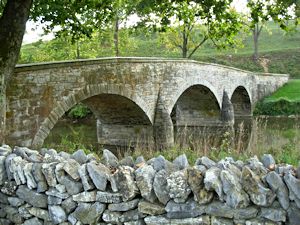
Burnsides Bridge, Antietam National Battlefield
Photo by Piotrus, GFDL, via Wikimedia Commons
Antietam National Battlefield is a National Park Service protected area along Antietam Creek in Sharpsburg, Washington County, northwestern Maryland. It commemorates the American Civil War Battle of Antietam that occurred on September 17, 1862. The area, situated on fields among the Appalachian foothills near the Potomac River, features the battlefield site and visitor center, Antietam National Military Cemetery, stone arch Burnside’s Bridge, and a field hospital museum.
Big Hole National Battlefield
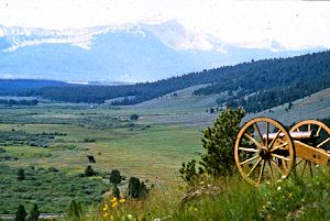
Big Hole National Battlefield
Photo Courtesy NPS
Big Hole National Battlefield preserves a Nez Perce War battlefield located in Montana, United States. The Nez Percé fought a delaying action against the 7th Infantry Regiment (United States) here on August 9 and 10, 1877, during their failed attempt to escape to Canada. This action, the Battle of the Big Hole, was the largest battle fought between the Nez Percé and U.S. Government forces in the five-month conflict known as the Nez Perce War. In 1992 the park was made a part of Nez Perce National Historical Park, which consists of 38 separate locations in five different states, following the flight of the Nez Percé tribe from the U.S. Cavalry.
Cowpens National Battlefield
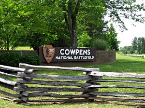
Cowpens National Battlefield
Photo Courtesy of Ken Lund via Flickr
Cowpens National Battlefield is a unit of the National Park Service just east of Chesnee, South Carolina, and near the state line with North Carolina. It preserves a major battlefield of the American Revolutionary War. Brigadier General Daniel Morgan won the Battle of Cowpens, a decisive Revolutionary War victory over British Lieutenant Colonel Banastre Tarleton on January 17, 1781.
Fort Donelson National Battlefield
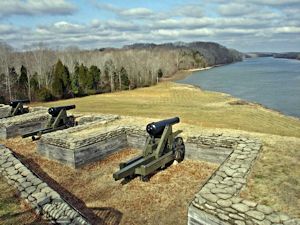
Fort Donelson National Battlefield
Photo by Hal Jespersen, GFDL, via Wikimedia
Fort Donelson National Battlefield preserves Fort Donelson in Dover, Tennessee, and Fort Heiman, in nearby Calloway County, Kentucky, two Confederate sites of the American Civil War where Union Army Brigadier General Ulysses S. Grant and Flag Officer Andrew Hull Foote captured three Confederate forts and opened two rivers, the Tennessee River and the Cumberland River, to control by the Union Navy. The capture of Fort Donelson and its garrison by the Union led to the capture of Tennessee’s capital and industrial center, Nashville, and gave the Union effective control over much of Tennessee. This struck a major blow to the Confederacy early in the war.
Fort Necessity National Battlefield

Photo by Anita Gould via Flickr
Fort Necessity National Battlefield is a National Battlefield Site in Fayette County, Pennsylvania, United States, which preserves the site of the Battle of Fort Necessity. The battle, which took place on July 3, 1754, was an early battle of the French and Indian War, and resulted in the surrender of British colonial forces under Colonel George Washington, to the French and Indians, under Louis Coulon de Villiers. The site also includes the Mount Washington Tavern, once one of the inns along the National Road, and in two separate units the grave of the British General Edward Braddock, killed in 1755, and the site of the Battle of Jumonville Glen.
Monocacy National Battlefield
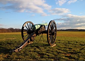
Photo by Mr. TinDC, (CC BY-ND 2.0) via Flickr
Monocacy National Battlefield is the site of the Battle of Monocacy in the American Civil War fought on July 9, 1864. The battlefield straddles the Monocacy River southeast of the city of Frederick, Maryland. The battle, labeled “The Battle That Saved Washington,” was one of the last the Confederates would carry out in Union territory. The two opposing leaders were General Jubal Early, fighting for the South, and General Lew Wallace, fighting for the North.
Moores Creek National Battlefield

Photo Courtesy NPS
Moores Creek National Battlefield commemorates the 1776 victory by a thousand Patriots over about eight hundred Loyalists at the Battle of Moore’s Creek Bridge, which is located in the Wilmington area near Currie in Pender County in southeastern North Carolina. The battle dashed the hopes of Royal Governor Josiah Martin of the Province of North Carolina for regaining control of the colony for the British crown. The Loyalist defeat ended British plans for an invasionary force to land in Brunswick Town, North Carolina. North Carolina voted to declare independence from the British on April 12, 1776, shortly after the victory at Moore’s Creek. The park was established as a National Military Park on June 2, 1926 and was redesignated as a National Battlefield on September 8, 1980.
Petersburg National Battlefield
Photo by Ken Lund, (CC BY-SA 2.0), via Flickr
Petersburg National Battlefield preserves sites related to the American Civil War Siege of Petersburg (1864–65). The Petersburg Battlefield is centered on the city of Petersburg, Virginia, and also includes Poplar Grove National Cemetery and outlying components in Hopewell (City Point served as a major command and logistics hub for the Union Army during the Siege of Petersburg), Prince George County, and Dinwiddie County (Five Forks Battlefield). A motor tour route runs from Virginia Route 36 to US Route 301. Along the way, visitors can view sites such as Fort Stedman and The Crater.
Stones River National Battlefield
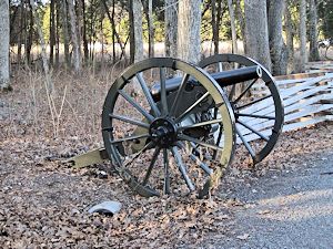
Photo by Thomas R Machnitzki, GFDL, via Wikimedia
Stones River National Battlefield, along the Stones River in Rutherford County, Tennessee, three miles (5 km) northwest of Murfreesboro and twenty-eight miles southeast of Nashville, memorializes the Battle of Stones River, a key battle of the American Civil War that took place on December 31, 1862 and January 2, 1863, which resulted in a strategic Union victory. Wooden signs mark and interpret battlefield locations. In 1992, the park accepted a donation from the City of Murfreesboro of an intact segment of Fortress Rosecrans, the largest enclosed earthwork built during the Civil War.
Tupelo National Battlefield
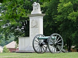
Photo by Chris Light, (CC BY-SA 3.0), via Wikimedia
Tupelo National Battlefield, in Tupelo, Mississippi, commemorates the July 14–15, 1864, Battle of Tupelo in which Lieutenant General Nathan Bedford Forrest tried to cut the railroad supplying the Union’s march on Atlanta. Disorganized Confederate soldiers fought fiercely but could not overpower the federal troops. Neither side could claim a clear victory, but Union troops had succeeded in their main goal: keeping the Confederates away from Union railroads in Tennessee.
Wilson’s Creek National Battlefield
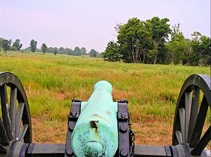
Photo by JeromeG111, (CC BY-SA 2.0), via Flickr
Wilson’s Creek National Battlefield near Republic, Missouri, preserves the site of the Battle of Wilson’s Creek. Fought on August 10, 1861, it was the first major American Civil War engagement west of the Mississippi River. The Confederate’s failure to exploit their victory here resulted in keeping Missouri in the Union. Major features include a 5-mile automobile tour loop, the restored 1852 Ray House, and “Bloody Hill,” the scene of the major battle. The site is located just southwest of the city of Springfield, in southwestern Missouri.
Subcategories
Article Index:
Antietam National Battlefield
Antietam National Battlefield is a National Park Service protected area along Antietam Creek in Sharpsburg, Washington County, northwestern Maryland. It commemorates the American Civil War Battle of Antietam that occurred on September 17, 1862.
The area, situated on fields among the Appalachian foothills near the Potomac River, features the battlefield site and visitor center, Antietam National Military Cemetery, stone arch Burnside’s Bridge, and a field hospital museum.
Horseshoe Bend National Military Park
Horseshoe Bend National Military Park is the location of a major battle with the Red Stick Creek Indians and General Andrew Jackson’s army along the Tallapoosa River in Alabama, which ended the Creek Indian Wars.
In March 1814, General Jackson’s army left Fort Williams on the Coosa, cut a 52-mile trail through the forest in three days, and on the 26th made camp six miles north of Horseshoe Bend.