One of the most influential figures in the history of American public lands, Roosevelt’s legacy is recognized at national parks, wildlife refuges, wilderness areas and national forests across the country. Theodore Roosevelt National Park is in the colorful North Dakota badlands.
Roosevelt first came to the badlands in September 1883 on a hunting trip. While here he became interested in the cattle business and invested in the Maltese Cross Ranch. He returned the next year and established the Elkhorn Ranch.
Whenever he managed to spend time in the badlands, he became more and more alarmed by the damage that was being done to the land and its wildlife. He witnessed the virtual destruction of some big game species, such as bison and bighorn sheep.
Overgrazing destroyed the grasslands and with them the habitats for small mammals and songbirds. Conservation increasingly became one of Roosevelt’s major concerns.
During his Presidency, Roosevelt established the US Forest Service and signed the 1906 Antiquities Act under which he proclaimed 18 national monuments. He also established 5 national parks, 51 wildlife refuges and 150 national forests.
Theodore Roosevelt National Park is beautiful at all times of the year. Wildlife found in the park includes bison, pronghorn antelope, elk, and wild horses.
Click image to enlarge.
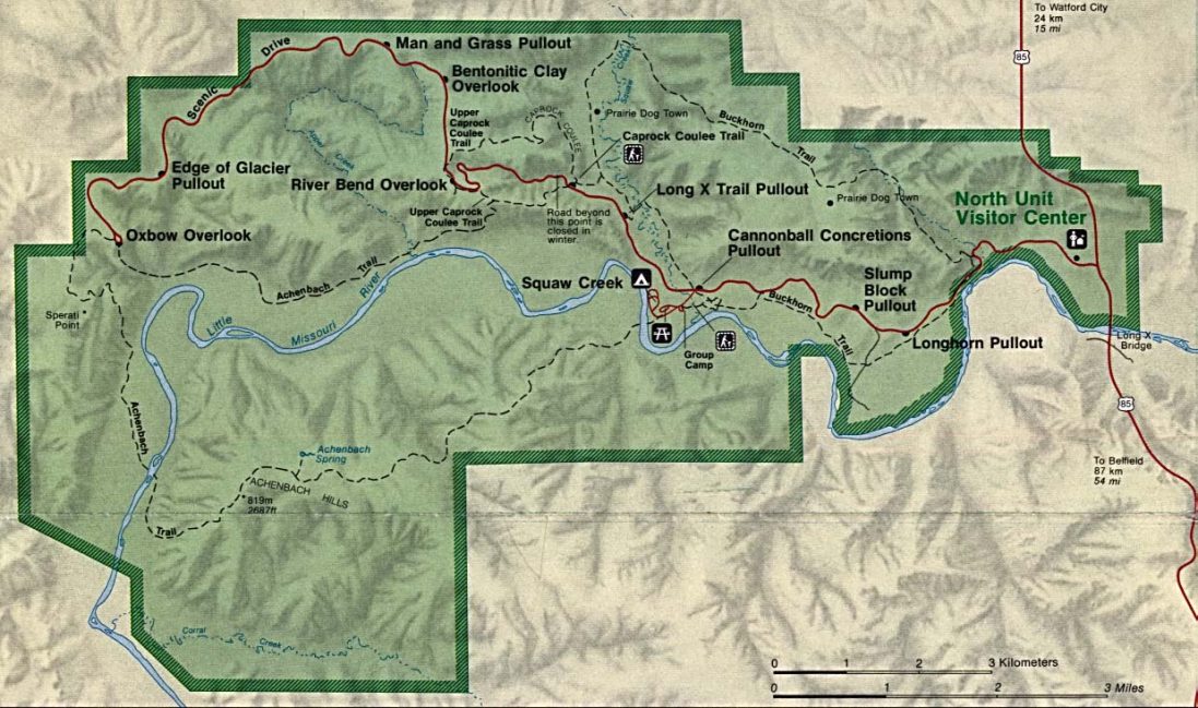
There are three distinct units in Theodore Roosevelt National Park. The south unit is the largest and contains two visitor centers, the main one near Medora, North Dakota, and the second at the Painted Desert.
There is a second unit at the Elkhorn Ranch, which was Teddy’s place during most of his ranch and cowboy days here, and a third in the North Unit, which also has a visitor center near the town of Watford City.
There are two scenic drives to take, ranger guided tours, camping, fishing, and a whole lot of beauty and history in this North Dakota paradise.
Geologic Features
Geologic Formations
Talkington Trail in Theodore Roosevelt National Park.
Photo courtesy of Matt Zimmerman via Flickr. Click image to enlarge.
As you drive or hike through western North Dakota, the gently rolling hills open up dramatically into the varied and colorful layers of the badlands. Curiosity might lead you to take a closer look at the rocks making up the layers. This closer look takes you back millions of years to an ancient world of swamps and forests.
The story of the badlands begins over 65 million years ago during the Paleocene Epoch. The dinosaurs had just become extinct at the end of the Cretaceous Period.
The western half of North America was buckling and folding to create the Rocky Mountains. Large amounts of sediments were forming as water, wind, and freezing worked to break down the mountains.
These sediments, mostly sand, silt, and mud, were carried off the eastern slopes by ancient rivers and deposited here in layers. Volcanoes in South Dakota, Montana, Idaho, and across the west were also erupting during this time, spitting out huge amounts of ash.
Some of this volcanic ash was blown or carried by rivers into North Dakota and accumulated in standing water. Over time, the sediments turned into the sandstone, siltstone, and mudstone layers now exposed in the park, while the ash layers became bentonite clay.
During the epochs that followed, the land continued to change. Deposition from the mountains in the west continued throughout much of the Eocene, Oligocene, and Miocene epochs. Then as the Pliocene Epoch began, erosion dominated and the layers began to be stripped away.
Rivers meandered through broad, shallow valleys across the western Dakotas and eastern Montana plains. Although the rivers changed their courses many times, when the Pliocene Epoch came to a close about two million years ago, one of these rivers existed in almost the same position as the modern Little Missouri River.
This river flowed northward to merge first with the ancestral Yellowstone River near Williston, North Dakota, and then merged with the Missouri River, continuing northeastward through Saskatchewan and Manitoba to Hudson Bay.
In the Pleistocene Epoch, the time period of numerous Ice Ages, which began about two million years ago, great continental ice sheets advanced southward from present-day Canada and reached as far as the upper North Unit boundary in the park.
The ice blocked the flow of the north-flowing rivers, forcing them to create new courses eastward and southward, causing them to empty into the Mississippi River instead of Hudson Bay.
By the time the ice retreated, the northern portions of both the Little Missouri and Missouri rivers were entrenched in their new channels. The Little Missouri’s new course to the north followed a steeper course, causing the whole river to flow faster and begin cutting deeply into the land.
Slicing easily through the soft sedimentary rocks, the river and its tributaries carved the fantastically broken topography that is today’s badlands.
Glaciers / Glacial Features
 Although glaciers are not to be found in Theodore Roosevelt National Park, the evidence of their geologically recent presence is throughout the park’s landscape.
During the Pleistocene Ice Age, tremendous ice sheets advanced from the north, redirecting the course of the Little Missouri River. Its new course caused the Little Missouri to carve more sharply into the soft sedimentary rock in the badlands, creating much of the broken topography found throughout the park.
Direct evidence of the glaciers’ recent presence is found in the North Unit. There, at the north rim of the the Little Missouri River Valley, the Pleistocene ice sheets reached the southernmost point of their advance.
As the ice sheets stalled there, the conveyor belts of ice continued to transport rock from far away, depositing it at the foot of the glacier. Some of the rocks carried and deposited by the glaciers in this manner are called glacial erratics.
These rocks are particularly noticeable because they are made of granite, an igneous rock found nowhere else in Theodore Roosevelt National Park’s sedimentary rock layers.
A pullout along the North Unit Scenic Drive highlights the presence of glacial erratics.
The Fossil Record
You might wonder how scientists can tell how old the rocks are and what the environment was like when they formed. The sediments in the rocks give some clues, but the best clues are fossils.
The North Dakota badlands contain a wealth of fossil information including bands of lignite coal and petrified trees plus fossils of freshwater clams, snails, crocodiles, alligators, turtles, and champsosaurs.
Each fossil is like a piece in a giant puzzle that scientists have used to reconstruct the ancient history of the park. These clues indicate that the park was once on the eastern edge of a flat, swampy area covered with rivers that fanned out into a broad, sea-level delta.
This swampy region contained dense forests of sequoia, bald cypress, magnolia, and other water-loving trees growing in or near the shallow waters.
Leaves and branches would fall into the still waters of the swamps and build up until they formed a dense layer of vegetation called peat.
Over time, pressure from overlying sediments compacted the peat and caused chemical changes to transform it into a soft, woody-textured coal called lignite (from the Latin ligneous, meaning wood).
When Theodore Roosevelt lived in the badlands in the 1880s, he and his ranch hands shoveled lignite coal from the hillsides to use in their stove.
Some forests were buried by flood deposits or volcanic ash falls. When a plant or animal is buried quickly, it is protected from decaying and has a better chance of becoming a fossil.
Groundwater moving through the silica-rich volcanic ash and other sediments can dissolve the silica, or quartz. When this silica-rich water soaked into the trees, organic compounds in the wood were dissolved and replaced by very small crystals of quartz.
In some cases, the quartz crystals are so small that much of the internal structure of the trees is preserved, including the growth rings. This process of quartz replacing wood is called petrifaction.
If you have ever stood in the badlands on a hot, dry summer day or a freezing, blustery winter day, a warm, wet, and humid swamp might be the most opposite type of climate and environment you could imagine.
Despite its stark contrast with today, fossil evidence in Theodore Roosevelt National Park strongly suggests that a swampy environment is exactly what used to be here in today’s badlands.
The fossil record shows that in the Paleocene Epoch, just after the time of the dinosaurs, this area was a vast swamp teeming with turtles, crocodilians, and bald cypress trees.
A three-year cooperative paleontological survey conducted in Theodore Roosevelt National Park by the North Dakota Geological Survey shed light on this part of North Dakota’s geologic history.
The fossilized remains of a crocodile-like reptile named Champsosaurus were excavated from a hillside in the South Unit in October 1995 by Dr. John Hoganson, paleontologist with the North Dakota Geological Survey, and his assistant, Jonathan Campbell.
The ancient reptile once inhabited the fresh waters in what is now western North Dakota about 55 million years ago during the Paleocene epoch. At that time, the climate was subtropical, similar to that of present day Florida.
The long, narrow snout and large powerful back legs would have enabled the Champsosaurus to feed on fish, snails, mollusks and turtles. Paleontologists believe that this ten-foot-long predator spent much of its time submerged in water waiting for prey, much like modern crocodiles.
Champsosaurus could lunge from the bottom using its powerful back legs. A turtle shell with bite marks also found during this survey provides a vignette of life from this era.
During the paleontological inventory, more than two hundred fossil sites were identified and mapped from the rock layers known as the Sentinel Butte and Bullion Creek formations.
The sites contained two other partial Champsosaurskeletons plus numerous freshwater mollusk remains, turtles (snapping and soft-shelled), parts of crocodiles and alligators, and plant fossils.
The most common fossil found was petrified wood, including large tree stumps measuring seven to eight feet in diameter. It is believed that most of these trees were conifers, such as bald cypress and sequoia.
The paleontological investigation enhanced our view of the park’s geologic story. By identifying what creatures and plants existed here, one can get an impression of what life was like millions of years ago.
The Present Landscape
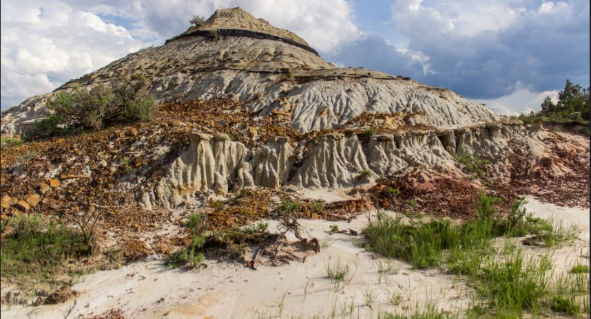
Geologic processes continue to shape the badlands. Yearly precipitation in the badlands averages 15 inches. Rain, though infrequent at times, usually comes in heavy, erosive downpours. Water running down slope forms gullies, while some soaks into clay-rich rocks and soils. The added weight of water sometimes causes portions of hill sides to break loose and flow downhill.
Lightning strikes and prairie fires can ignite coal beds, which then may burn for many years. When a coal bed burns, it bakes the overlying sediments into a hard, natural brick that geologists call clinker, but is locally called “scoria.”
The red color of the rock comes from the oxidation of iron released from the coal as it burns. The burning lends both color to the badlands and helps to shape them. These hardened rocks are more resistant to erosion than the unbaked rocks nearby.
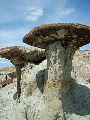
Rain Pillars. Photo courtesy NPS.
Over time, erosion has worn down the less resistant rocks, leaving behind a jumble of knobs, ridges, and buttes topped with durable red scoria caps.
Theodore Roosevelt National Park preserves a wealth of geologic information that can be enjoyed by visitors and studied by scientists. Much of that information tells us about events that occurred long ago, while some small-scale processes can be seen occurring over days, weeks, months, or even years.
You are welcome to explore Theodore Roosevelt National Park and make your own discoveries about the rocks and fossils found here. Please remember, however, that each rock and fossil may be a clue to the geologic history of the park, and must be left where they are found for other visitors to view and for scientists to study. Collecting of any park resource is not allowed.
Ecosystems
Flood Plains
The Little Missouri River is a prominent feature in all three units of Theodore Roosevelt National Park, and its floodplain is an important feature that contributes to the diversity of habitat, plants, and animals in the park.
The sediment-heavy Little Missouri River constantly winds within its banks, slowly changing course over the years. Periodically, the river overflows its banks and onto its floodplain. This periodic flooding has helped trees such as the cottonwood to become established on the floodplain.
The cottonwoods on the floodplain provide valuable habitat for other plants and for animals, too. White-tailed deer prefer the heavily wooded habitat of the cottonwood forests.
Numerous species of birds are attracted to the forests in the Little Missouri floodplain because of the diverse and abundant food sources and easy access to water. These large forests are home to year-round feathered residents such as black-capped chickadees, white-breasted nuthatches, and great-horned owls, and provide seasonal homes for nesting Baltimore orioles, waxwings, and a variety of warblers.
Porcupines and beavers also use the cottonwood trees themselves for cover and food.
The flat, grassy areas on the floodplains also provide grazing opportunities for the park’s numerous grazing mammals, including bison, deer, horses, and elk. Prairie dog towns are also located in some areas on the floodplain.
Forests
Forests are not the dominant habitat type in Theodore Roosevelt National Park, but they form an important component of the park’s habitat diversity. There are primarily two types of forests in the park: juniper woodlands and hardwood forests.
Rocky Mountain juniper woodlands are the most common forest type in the park because the junipers benefit from a microclimate created on the north face of the buttes. There, the sun’s heat is less intense and water evaporation is lower.
Conversely, the south faces of the buttes are hotter and drier, and junipers are less common. Juniper woodlands on the north faces of buttes also slow the effect of erosion, and the north faces of the hills are not as steep as the south faces where junipers are not prevalent.
Elk prefer juniper woodlands where they can escape the heat of summer and the cold winds of winter. The berries produced by junipers are a critical food source for birds including Townsend’s solitaires, cedar waxwings, bohemian waxwings, and American robins.
The dry climate of the North Dakota badlands limits the amount of hardwood forests. Hardwoods including green ash, American elm, box elder, and cottonwoods cling to the river bottoms and draws where water is more available.
These larger trees allow shrubby vegetation to grow beneath them, and the habitat favors some animals such as white-tailed deer, porcupines, and forest-dwelling birds.
Prairies and Grasslands
Grasslands are the most abundant habitat type found in Theodore Roosevelt National Park. Grasses are able to cope with the low annual precipitation, going dormant as the relatively wet spring gives way to the dry, hot summer.
At first glance, grasslands may appear monotonous, but, in fact, the grasslands encompass a rich and constantly changing diversity of plants and animals.

Wild horses in Theodore Roosevelt National Park. Photo courtesy of the NPS.
A native grasses and many species of forbs and shrubs comprise the most diverse array of plant life in the park. Grasses including saltgrass, Western wheatgrass, needle-and-thread, and little bluestem provide valuable forage for many grazing animals including bison, wild horses, elk, mule deer, and prairie dogs, not to mention a rich array of insect life.
The grazing animals and insects of the grassland in turn attract predators; prairie dogs are under constant threat from badgers, coyotes, hawks, and eagles, and insects are eaten by birds such as flycatchers and swallows.
Over time, woodier plants such as sagebrush and wild rose become established in grasslands, changing the forage available to grazing animals.
Periodic fire, whether natural or prescribed by the park, is necessary to improve habitat and forage diversity. Fires reduce woody vegetation and allow early successional grasses and forbs to re-establish themselves.
Rivers and Streams
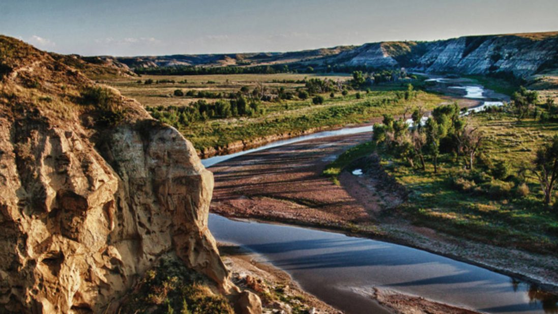
Photo courtesy of Kim Wehner, NPS. Click image to enlarge.
The Little Missouri River is a key feature of all three units of Theodore Roosevelt National Park. In the semi-arid environment of the badlands, the power of the river to shape the landscape and to sustain life underscore its importance.
The ever-changing Little Missouri River varies from a muddy trickle to a raging flood to a frozen highway at different times of the year. As the river carves through the soft clay of the badlands, it cuts away at its banks, constantly changing shape as it snakes northward to the Missouri River.
The Little Missouri River supports a wide variety of plants and animals. Beavers, catfish, minnows, a variety of ducks and geese, and occasionally bald eagles and white pelicans utilize the river.
The Little Missouri River represents the only aquatic environment in the park that can support fish. Many of the park’s large animals, such as bison, wild horses, and deer, find water in the river.
The flat lands adjacent to the Little Missouri River are part of its floodplain. These areas that occasionally flood are a unique habitat type in the park consisting of large cottonwood groves and meadows.
Some popular visitor activities on the Little Missouri River include float trips, fishing, and wildlife viewing. Great places to view the river include the Wind Canyon Overlook in the South Unit, and the River Bend Overlook and Oxbow Bend Overlook at the North Unit.
A number of small creeks also cut through the badlands. These streams feed rain and melting snow into the Little Missouri River.
Creeks may flow with water from storms, but can often be completely dry. The channels allow plants that need relatively more water to survive in the narrow channels, and provide wildlife with an often temporary source of drinking water.
The occasional mud makes for a great opportunity to find animal tracks, a record of the recent wild visitors to the area.
Theodore Roosevelt National Park
PO Box 7
Medora, ND 58645
Phone: (701) 623-4466