Black Fork Mountain Wilderness contains the rugged ridge of Black Fork Mountain, which is 13 miles long. It was designated by the United States Congress in 1984 and contains a total of 13,347 acres. Most of the land is in Arkansas, but some of the mountain ridge extends into Oklahoma.
Black Fork Mountain Wilderness
Established: 1984
States: Arkansas, Oklahoma
Management: U.S. Forest Service
Acres: 13,347 acres
Nearest Towns:
Page, Oklahoma
Eagle Gap, Arkansas
Large rock flows and sandstone bluffs stand above a forest dominated by oak and shortleaf pine. The northern slopes support hardwoods with an open understory. A forest of dwarf oaks adds to the cover of vegetation, which includes several unique plant species, such as serviceberry and granddaddy graybeard, hidden away in small coves.
There are no maintained trails on the Oklahoma side, and you’ll find the hiking to be challenging. The hiking on both sides is rated as difficult.
On the Arkansas side, the Black Fork Mountain Trail is 5.6 miles long each way, and passes several pioneer sites dating back to the late 1800s as it winds its way to the top of Black Fork Mountain, over 2,400 feet above sea level.
The mountain is actually a 13-mile-long east-west ridge, a geologic uplift that runs well into Oklahoma. The Wilderness boundary also follows the ridge into Oklahoma.
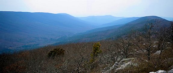
Some of the slopes near the top of the ridge on the Oklahoma side are nearly vertical. Rock scree slopes flow off in many locations. In both states the ridge rises to scenic overlooks that offer spectacular views of the region.
Lower slopes are heavily forested with shortleaf pine, blackjack oaks, and ancient dwarf oaks. Some of the shrubs and trees in the area are seldom seen anywhere else in this region.
Beyond the Ouachita River and Big Creek, which border the Wilderness, the area holds no water except for two small springs on the mountain that flow most of the year.
The Black Fork Mountain Wilderness Area receives very few visitors each year, so it’s relatively easy to find solitude.
The Trail
Black Fork Mountain is built upon a thrust faulted spine of Jackfork sandstone that lies between Page, Oklahoma and Eagle Gap, Arkansas. Beginning at the southeast corner and covering the east fifth of the wilderness is the Black Fork Mountain Trail.
The one way trip to the top is 5.6 miles of mostly up hill hike. It starts at 1,550 feet and climbs to 2,510 by mile 3.6. Then it drops 400 feet off the south face of the ridge before climbing back up to the peak at 2,620 feet.
The trail begin at a trailhead parking lot on the north side of US 270, between the road up to Queen Wilhelmina State Park and Eagle Gap. The trailhead and the first mile of the trail is shared with the Ouachita Trail. The Black Fork Trail is blazed with white paint and the Ouachita Trail is blazed with blue.
From the parking lot, the trails drop immediately into a small valley formed by Big Creek. There is a very good foot bridge across the creek. From here is it is basically up hill for the next 3.5 miles.
Just above the creek are the tracks for the Kansas City Southern Railroad. This is a busy route and apparently close to a side track used for passing. The noise from the trains can be heard at the top of the mountain, at least until the wind picks up.
There were some places where the brush and briars tended to get thick, but overall, the trail is in great shape.
After the trail leaves the train tracks, it starts climbing in earnest. The forest for the first 2.5 miles is short leaf pine and hard wood mix. About one mile out, the trail intersects an old logging road.
It is here that the Ouachita Trail heads off to the east and the Black Fork heads up to the west. Although the trail follows the old road for the next mile and a half, it ranges from an eroded rocky road bed to a narrow path through the pines, all up hill.
At 2.1 miles is a pine stand with some level ground and a big fire pit. In the dry season there will be a nice flat spot that looks great for pitching a tent. Better hope it doesn’t rain because it was holding about 6 inches of water when we were there.
At 2.4 miles is a sign announcing the wilderness boundary and at 2.6 miles is what Tim Ernst describes in his trail guide as a frog pond. It is and there were plenty of frogs. As far as a drinking water source, it is probably perfectly fine once filtered, but you won’t find it an attractive proposition.
The trail goes through some piney areas bordered with outcrops of sandstone. At 3.2 miles, you will come out of the only switchback in the area and enter a slightly surreal forest of stunted oaks, lush grass and moss covered trail. Battered by the wind and weather, these trees are short, old and gnarled.
After winding around the head of a valley, the trail begins a 400 foot decent. Shortly after the decent begins, you squeeze between a tree and some rocks and pass an outstanding outcrop of near vertical Jackfork sandstone.
At the bottom of the downhill, the trail joins another trail coming up from the southeast. The Black Fork joins this trail, so turn right (west) and head up hill.
At 4.4 miles we crossed a small stream. When we were there, there had been lots of rain and snow in the previous months so I don’t know how dependable this water source is. It is the Ouachitas, however, so it is probably dry once the summer dry season arrives.
Once you get past the creek you should be able to see the rock glaciers piled up in the basin. This much rock is pretty rare in this part of the country and would be worth a visit.
The trail continues climbing, and after about a mile, and just before reaching the top, is a great vista where you see the valley where US 270 runs and Queen Wilhelmina Lodge on top of Rich Mountain.
A few hundred feet further is a saddle covered with stunted oaks and grass, a big fire ring and an excellent place to camp. Another hundred feet and there is a cairn marking a side trail to what Ernst called a spring fed pond. It is spring fed, but when we were there, it had so much bloom and so many frogs, it was a toss up as to which pond had the best water.
With all the rain, the spring was active and there was a nice pool of clear sweet water in the short creek connecting the seep and the pond. If the spring is dry, you might be able to take water below the exit side of the pond. We heard it running that night but it was too dark to see what it looked like.
About 0.1 miles past the saddle is a chimney. It is poorly built with large holes between the rocks and no sign of mortar or dirt caulk. It must have been a lot of work to build it, but it doesn’t look like the other chimneys found in the Ouachitas and Ozarks.
The trail narrows as it reaches the peak at the terminus. The view is excellent. We bushwhacked a little further west to the true peak and found an even better vista and a 360 degree view. But it was an effort.
From the top you can see spectacular views of Queen Wilhelmina State Park, Rich Mountain Fire Tower and the Ouachita Mountains in Arkansas and Oklahoma.
The oaks here are only about 4 to 6 feet tall. The area is extremely rocky and the ground is covered with a mesh of briars.
This hike takes about 3 hours each way, so a day hiker can do it in a day.
Restrictions
Use of wagons, carts or other wheeled vehicles is prohibited. This includes the use of motor vehicles, motorboats, motorized equipment, bicycles, hang gliders, wagons, carts, portage wheels, and the landing of aircraft including helicopters, unless provided for in specific legislation.